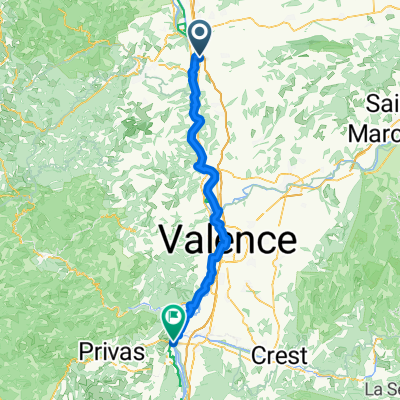
France2023 E9
A cycling route starting in Andancette, Auvergne-Rh么ne-Alpes, France.
Overview
About this route
Andance - La Vaulte sur Rh么ne Narbousset
- -:--
- Duration
- 78.7 km
- Distance
- 280 m
- Ascent
- 290 m
- Descent
- ---
- Avg. speed
- 138 m
- Avg. speed
Route quality
Waytypes & surfaces along the route
Waytypes
Cycleway
32.7 km
(42 %)
Quiet road
15.4 km
(20 %)
Surfaces
Paved
43.1 km
(55 %)
Unpaved
3.6 km
(5 %)
Asphalt
42.2 km
(54 %)
Gravel
1.9 km
(2 %)
Continue with Bikemap
Use, edit, or download this cycling route
You would like to ride France2023 E9 or customize it for your own trip? Here is what you can do with this Bikemap route:
Free features
- Save this route as favorite or in collections
- Copy & plan your own version of this route
- Sync your route with Garmin or Wahoo
Premium features
Free trial for 3 days, or one-time payment. More about Bikemap Premium.
- Navigate this route on iOS & Android
- Export a GPX / KML file of this route
- Create your custom printout (try it for free)
- Download this route for offline navigation
Discover more Premium features.
Get Bikemap PremiumFrom our community
Other popular routes starting in Andancette
- J4D RC2 MIPIM 2018
- Distance
- 41.9 km
- Ascent
- 101 m
- Descent
- 124 m
- Location
- Andancette, Auvergne-Rh么ne-Alpes, France
- V-2. Saint Rambert d'Albon - Valence
- Distance
- 51.4 km
- Ascent
- 147 m
- Descent
- 178 m
- Location
- Andancette, Auvergne-Rh么ne-Alpes, France
- Andancette Sablons et plus loin
- Distance
- 37.4 km
- Ascent
- 32 m
- Descent
- 34 m
- Location
- Andancette, Auvergne-Rh么ne-Alpes, France
- Etape 7
- Distance
- 29.9 km
- Ascent
- 52 m
- Descent
- 83 m
- Location
- Andancette, Auvergne-Rh么ne-Alpes, France
- 4 Route nach Viviers
- Distance
- 120 km
- Ascent
- 464 m
- Descent
- 499 m
- Location
- Andancette, Auvergne-Rh么ne-Alpes, France
- Champagne-Saint-Genis-Laval
- Distance
- 66.7 km
- Ascent
- 358 m
- Descent
- 275 m
- Location
- Andancette, Auvergne-Rh么ne-Alpes, France
- France2023 E9
- Distance
- 78.7 km
- Ascent
- 280 m
- Descent
- 290 m
- Location
- Andancette, Auvergne-Rh么ne-Alpes, France
- 2017-21 f茅vrier andancette
- Distance
- 20.9 km
- Ascent
- 26 m
- Descent
- 29 m
- Location
- Andancette, Auvergne-Rh么ne-Alpes, France
Open it in the app