

vuelta a najquitob, cruce del Cid.
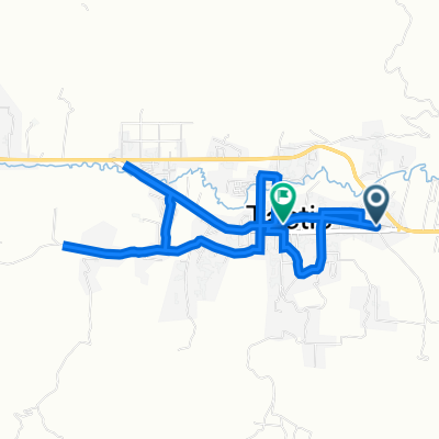
A cycling route starting in Tactic, Alta Verapaz Department, Guatemala.
Overview
About this route
- 1 h 52 min
- Duration
- 20.5 km
- Distance
- 263 m
- Ascent
- 267 m
- Descent
- 11 km/h
- Avg. speed
- 1,677 m
- Max. altitude

Route photos


Route quality
Waytypes & surfaces along the route
Waytypes
Quiet road
12.5 km
(61 %)
Cycleway
5.3 km
(26 %)
Surfaces
Paved
5.3 km
(26 %)
Asphalt
5.3 km
(26 %)
Undefined
15.2 km
(74 %)
Continue with Bikemap
Use, edit, or download this cycling route
You would like to ride vuelta a najquitob, cruce del Cid. or customize it for your own trip? Here is what you can do with this Bikemap route:
Free features
- Save this route as favorite or in collections
- Copy & plan your own version of this route
- Sync your route with Garmin or Wahoo
Premium features
Free trial for 3 days, or one-time payment. More about Bikemap Premium.
- Navigate this route on iOS & Android
- Export a GPX / KML file of this route
- Create your custom printout (try it for free)
- Download this route for offline navigation
Discover more Premium features.
Get Bikemap PremiumFrom our community
Other popular routes starting in Tactic
 Finca Santa Sofía
- Distance
- 8.7 km
- Ascent
- 171 m
- Descent
- 167 m
- Location
- Tactic, Alta Verapaz Department, Guatemala
 Cumbre Tactic
- Distance
- 8.3 km
- Ascent
- 807 m
- Descent
- 805 m
- Location
- Tactic, Alta Verapaz Department, Guatemala
 najkitop
- Distance
- 15.8 km
- Ascent
- 269 m
- Descent
- 273 m
- Location
- Tactic, Alta Verapaz Department, Guatemala
 Montaña Chojol
- Distance
- 10.7 km
- Ascent
- 283 m
- Descent
- 287 m
- Location
- Tactic, Alta Verapaz Department, Guatemala
 Colazo nocturno Bomberos Voluntarios
- Distance
- 9.4 km
- Ascent
- 78 m
- Descent
- 87 m
- Location
- Tactic, Alta Verapaz Department, Guatemala
 entrenamiento nocturno femenino No.3
- Distance
- 4.8 km
- Ascent
- 47 m
- Descent
- 47 m
- Location
- Tactic, Alta Verapaz Department, Guatemala
 Atletismo
- Distance
- 4.4 km
- Ascent
- 71 m
- Descent
- 71 m
- Location
- Tactic, Alta Verapaz Department, Guatemala
 Runing
- Distance
- 4.5 km
- Ascent
- 30 m
- Descent
- 34 m
- Location
- Tactic, Alta Verapaz Department, Guatemala
Open it in the app