

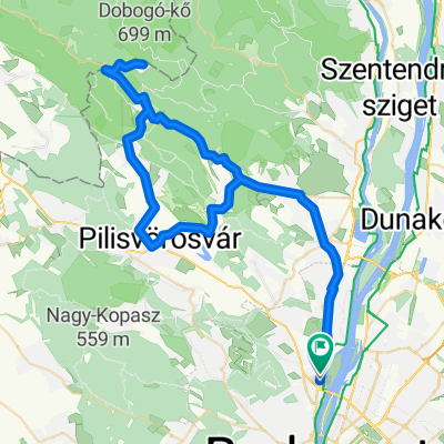
Budai hegyek tekergés
A cycling route starting in Óbuda-Békásmegyer, Budapest, Hungary.
Overview
About this route
Riding in the Buda hills, stopping by: Virágos Nyereg, Nagykovácsi, Nagykopasz, Budakeszi, Sorrento rocks, Budaörs
- -:--
- Duration
- 50.6 km
- Distance
- 862 m
- Ascent
- 861 m
- Descent
- ---
- Avg. speed
- ---
- Max. altitude
Continue with Bikemap
Use, edit, or download this cycling route
You would like to ride Budai hegyek tekergés or customize it for your own trip? Here is what you can do with this Bikemap route:
Free features
- Save this route as favorite or in collections
- Copy & plan your own version of this route
- Sync your route with Garmin or Wahoo
Premium features
Free trial for 3 days, or one-time payment. More about Bikemap Premium.
- Navigate this route on iOS & Android
- Export a GPX / KML file of this route
- Create your custom printout (try it for free)
- Download this route for offline navigation
Discover more Premium features.
Get Bikemap PremiumFrom our community
Other popular routes starting in Óbuda-Békásmegyer
 Bp - Pilisszentlászló - Kisrigó - Dömörkapu - Bp
- Distance
- 60.7 km
- Ascent
- 394 m
- Descent
- 394 m
- Location
- Óbuda-Békásmegyer, Budapest, Hungary
 Budai hegyek tekergés
- Distance
- 50.6 km
- Ascent
- 862 m
- Descent
- 861 m
- Location
- Óbuda-Békásmegyer, Budapest, Hungary
 Coffee Ride - Csobánka Szántó Dobogókő
- Distance
- 74.3 km
- Ascent
- 716 m
- Descent
- 720 m
- Location
- Óbuda-Békásmegyer, Budapest, Hungary
 Coffee Ride - Paprét + Szentkereszt
- Distance
- 73.1 km
- Ascent
- 730 m
- Descent
- 728 m
- Location
- Óbuda-Békásmegyer, Budapest, Hungary
 Alternatív rövid könnyű útvonal
- Distance
- 34.1 km
- Ascent
- 211 m
- Descent
- 207 m
- Location
- Óbuda-Békásmegyer, Budapest, Hungary
 CR - Paprét - Pilisszentkereszt - Dobogókő
- Distance
- 83.8 km
- Ascent
- 914 m
- Descent
- 913 m
- Location
- Óbuda-Békásmegyer, Budapest, Hungary
 Teca kocsmája a hegyen át
- Distance
- 101.4 km
- Ascent
- 803 m
- Descent
- 803 m
- Location
- Óbuda-Békásmegyer, Budapest, Hungary
 CR - Skanzen kör
- Distance
- 44.8 km
- Ascent
- 169 m
- Descent
- 166 m
- Location
- Óbuda-Békásmegyer, Budapest, Hungary
Open it in the app