

Sortie vélo Pont du Bouc Forêt de la Hardt 56 km
A cycling route starting in Rixheim, Grand Est, France.
Overview
About this route
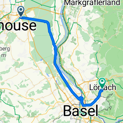
Departure from the Pont du Bouc then Hardt Forest - Fessenheim - Germany - Ottmarsheim and return to Pont du Bouc
- -:--
- Duration
- 55.9 km
- Distance
- 147 m
- Ascent
- 146 m
- Descent
- ---
- Avg. speed
- 237 m
- Max. altitude

Route quality
Waytypes & surfaces along the route
Waytypes
Track
17.3 km
(31 %)
Access road
8.9 km
(16 %)
Surfaces
Paved
40.2 km
(72 %)
Unpaved
12.9 km
(23 %)
Asphalt
39.7 km
(71 %)
Gravel
10.6 km
(19 %)
Continue with Bikemap
Use, edit, or download this cycling route
You would like to ride Sortie vélo Pont du Bouc Forêt de la Hardt 56 km or customize it for your own trip? Here is what you can do with this Bikemap route:
Free features
- Save this route as favorite or in collections
- Copy & plan your own version of this route
- Sync your route with Garmin or Wahoo
Premium features
Free trial for 3 days, or one-time payment. More about Bikemap Premium.
- Navigate this route on iOS & Android
- Export a GPX / KML file of this route
- Create your custom printout (try it for free)
- Download this route for offline navigation
Discover more Premium features.
Get Bikemap PremiumFrom our community
Other popular routes starting in Rixheim
 20141012_102039.gpx
- Distance
- 27 km
- Ascent
- 394 m
- Descent
- 394 m
- Location
- Rixheim, Grand Est, France
 De 10 Impasse des Cèdres, Rixheim à 10 Impasse des Cèdres, Rixheim
- Distance
- 33.7 km
- Ascent
- 139 m
- Descent
- 137 m
- Location
- Rixheim, Grand Est, France
 Sortie Vélo Lions
- Distance
- 54.5 km
- Ascent
- 111 m
- Descent
- 113 m
- Location
- Rixheim, Grand Est, France
 mulhaus - Montepiller
- Distance
- 952.8 km
- Ascent
- 2,453 m
- Descent
- 2,673 m
- Location
- Rixheim, Grand Est, France
 Rue de la Navigation nach Weinbrennerstraße
- Distance
- 39.3 km
- Ascent
- 109 m
- Descent
- 51 m
- Location
- Rixheim, Grand Est, France
 Sortie vélo Pont du Bouc Forêt de la Hardt 56 km
- Distance
- 55.9 km
- Ascent
- 147 m
- Descent
- 146 m
- Location
- Rixheim, Grand Est, France
 BRS brevet randonneur du sundgau
- Distance
- 194.7 km
- Ascent
- 1,061 m
- Descent
- 1,060 m
- Location
- Rixheim, Grand Est, France
 Brevet Audax 300 Mulhouse 18/05/2014
- Distance
- 301.1 km
- Ascent
- 1,189 m
- Descent
- 1,189 m
- Location
- Rixheim, Grand Est, France
Open it in the app