- 64.5 km
- 312 m
- 521 m
- Lauchringen, Baden-Wurttemberg, Germany
Äulemer Kreuz - Lauchringen -Rundfahrt
A cycling route starting in Lauchringen, Baden-Wurttemberg, Germany.
Overview
About this route
The route is ideal for training. It features some climbs, which allows for plenty of time to recover.
Apart from a few parallel bike paths, you ride on the road, which is not heavily trafficked.
It’s an ideal training loop, no matter where you start and which direction you take. Riding clockwise, you have a nice, steady climb from the Rhine.
Have fun descending.
- -:--
- Duration
- 99.9 km
- Distance
- 1,567 m
- Ascent
- 1,497 m
- Descent
- ---
- Avg. speed
- 1,156 m
- Max. altitude
created this 16 years ago
Route quality
Waytypes & surfaces along the route
Waytypes
Quiet road
18 km
(18 %)
Road
8 km
(8 %)
Surfaces
Paved
73 km
(73 %)
Unpaved
6 km
(6 %)
Asphalt
71 km
(71 %)
Ground
5 km
(5 %)
Route highlights
Points of interest along the route
Point of interest after 0 km
Continue with Bikemap
Use, edit, or download this cycling route
You would like to ride Äulemer Kreuz - Lauchringen -Rundfahrt or customize it for your own trip? Here is what you can do with this Bikemap route:
Free features
- Save this route as favorite or in collections
- Copy & plan your own version of this route
- Split it into stages to create a multi-day tour
- Sync your route with Garmin or Wahoo
Premium features
Free trial for 3 days, or one-time payment. More about Bikemap Premium.
- Navigate this route on iOS & Android
- Export a GPX / KML file of this route
- Create your custom printout (try it for free)
- Download this route for offline navigation
Discover more Premium features.
Get Bikemap PremiumFrom our community
Other popular routes starting in Lauchringen
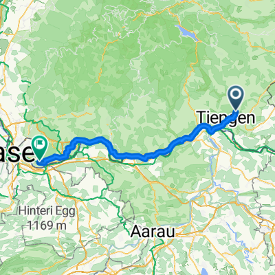
- Koblenz AG - Mülhausen
- 3-TagesTour 3 - Waldshut Küsnacht
- 85.7 km
- 1,280 m
- 1,176 m
- Lauchringen, Baden-Wurttemberg, Germany
- Lauchringen - Böbikon - Klingnau
- 38.7 km
- 607 m
- 604 m
- Lauchringen, Baden-Wurttemberg, Germany
- Lauchringen - Wangen b. Olten
- 70.8 km
- 489 m
- 442 m
- Lauchringen, Baden-Wurttemberg, Germany
- Schaffhauser Straße, Waldshut-Tiengen to Schönbeinstrasse, Basel
- 79 km
- 458 m
- 525 m
- Lauchringen, Baden-Wurttemberg, Germany
- Lauchringen - Olten
- 68.4 km
- 476 m
- 446 m
- Lauchringen, Baden-Wurttemberg, Germany
- Hauptstraße, Waldshut-Tiengen nach Markgrafenstraße, Lörrach
- 69.7 km
- 594 m
- 630 m
- Lauchringen, Baden-Wurttemberg, Germany
- Hochrhein Fluss aufwärts. zurück durch die Schweiz
- 25.8 km
- 54 m
- 57 m
- Lauchringen, Baden-Wurttemberg, Germany
Open it in the app


