
Venusberg - Kottenforst MTB Runde
A cycling route starting in Bonn, North Rhine-Westphalia, Germany.
Overview
About this route
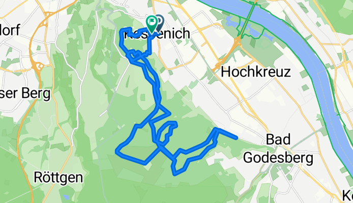
Start ist in Kessenich und geradewegs den Rosenburgweg zum Sendemast hoch. Dieser erste Anstieg hat es schon gewaltig in sich und könnte so manchem Neuling den Spass verderben. Ist man erst mal oben hat man genügend Zeit sich auf den Flachstücken zu erholen. Auf etwa halber Strecke kommt dann die Abfahrt nach Bad Godesberg. Nach einer Spitzkehre folgt dann wieder der Anstieg zum Kottenforst. Es gibt dann nochmalk eine kleine Schlaufe nähe Annabergerstr. bevor es dann am Sendemast zu Ausgangspunkt zurückgeht.
Die Tour kreuzt sich gelegentlich, es wird aber kaum etwas doppelt gefahren. Dauer ca. 1,5 Std. 19,44km, knappe 764 Höhenmeter und schöne Aussichten.
- -:--
- Duration
- 19.4 km
- Distance
- 350 m
- Ascent
- 347 m
- Descent
- ---
- Avg. speed
- ---
- Avg. speed
Continue with Bikemap
Use, edit, or download this cycling route
You would like to ride Venusberg - Kottenforst MTB Runde or customize it for your own trip? Here is what you can do with this Bikemap route:
Free features
- Save this route as favorite or in collections
- Copy & plan your own version of this route
- Sync your route with Garmin or Wahoo
Premium features
Free trial for 3 days, or one-time payment. More about Bikemap Premium.
- Navigate this route on iOS & Android
- Export a GPX / KML file of this route
- Create your custom printout (try it for free)
- Download this route for offline navigation
Discover more Premium features.
Get Bikemap PremiumFrom our community
Other popular routes starting in Bonn
 Lockere 1Stunde rund und in Beuel
- Distance
- 21.3 km
- Ascent
- 182 m
- Descent
- 168 m
- Location
- Bonn, North Rhine-Westphalia, Germany
 kleine McDrive-Runde (Ittenbach)
- Distance
- 40.7 km
- Ascent
- 437 m
- Descent
- 437 m
- Location
- Bonn, North Rhine-Westphalia, Germany
 Flach um Bonn
- Distance
- 56.6 km
- Ascent
- 186 m
- Descent
- 186 m
- Location
- Bonn, North Rhine-Westphalia, Germany
 Bonn - Stadt Blankenberg
- Distance
- 79.5 km
- Ascent
- 846 m
- Descent
- 846 m
- Location
- Bonn, North Rhine-Westphalia, Germany
 BRT2016-FR: An Rhein und Sieg - RTF des Radsportbezirk Mittelrhein-Süd beim BRT 2016 in Bonn - 105 km Strecke einer Pfeil-Such-Fahrt
- Distance
- 104.9 km
- Ascent
- 1,022 m
- Descent
- 1,023 m
- Location
- Bonn, North Rhine-Westphalia, Germany
 BRT2016-MI: In den Westerwald - PSF des Radsportbezirk Mittelrhein-Süd beim BRT 2016 in Bonn - 70 km Strecke
- Distance
- 76.8 km
- Ascent
- 561 m
- Descent
- 561 m
- Location
- Bonn, North Rhine-Westphalia, Germany
 Auf den Feldern zwischen Köln und Troisdorf
- Distance
- 29.5 km
- Ascent
- 23 m
- Descent
- 24 m
- Location
- Bonn, North Rhine-Westphalia, Germany
 Bonn - Eifel - Westerwald - Bonn
- Distance
- 189.7 km
- Ascent
- 1,343 m
- Descent
- 1,341 m
- Location
- Bonn, North Rhine-Westphalia, Germany
Open it in the app