
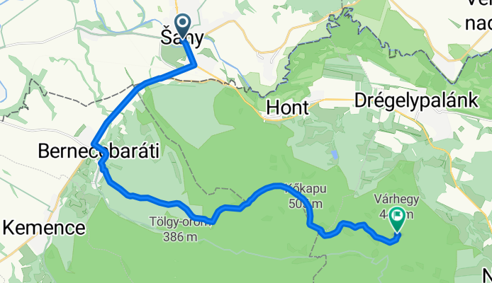
Šahy - Homok - Berneceberáti - Major kereszt - hrad Drégely (HU)
A cycling route starting in Šahy, Nitra Region, Slovakia.
Overview
About this route
Asfalt - cesty, polne / lesne cesty
- -:--
- Duration
- 17.7 km
- Distance
- 486 m
- Ascent
- 190 m
- Descent
- ---
- Avg. speed
- 491 m
- Max. altitude

Route quality
Waytypes & surfaces along the route
Waytypes
Track
9.4 km
(53 %)
Road
2.7 km
(15 %)
Surfaces
Paved
6 km
(34 %)
Unpaved
9.2 km
(52 %)
Ground
9.2 km
(52 %)
Asphalt
6 km
(34 %)
Undefined
2.5 km
(14 %)
Continue with Bikemap
Use, edit, or download this cycling route
You would like to ride Šahy - Homok - Berneceberáti - Major kereszt - hrad Drégely (HU) or customize it for your own trip? Here is what you can do with this Bikemap route:
Free features
- Save this route as favorite or in collections
- Copy & plan your own version of this route
- Sync your route with Garmin or Wahoo
Premium features
Free trial for 3 days, or one-time payment. More about Bikemap Premium.
- Navigate this route on iOS & Android
- Export a GPX / KML file of this route
- Create your custom printout (try it for free)
- Download this route for offline navigation
Discover more Premium features.
Get Bikemap PremiumFrom our community
Other popular routes starting in Šahy
 Nagyoknak , 16km/460m szint
- Distance
- 15.9 km
- Ascent
- 514 m
- Descent
- 524 m
- Location
- Šahy, Nitra Region, Slovakia
 Börzsöny Drégelyvár 3
- Distance
- 56.8 km
- Ascent
- 690 m
- Descent
- 690 m
- Location
- Šahy, Nitra Region, Slovakia
 Sahy - Sitno - Levice
- Distance
- 120.8 km
- Ascent
- 1,611 m
- Descent
- 1,589 m
- Location
- Šahy, Nitra Region, Slovakia
 Börzsöny tour
- Distance
- 64 km
- Ascent
- 587 m
- Descent
- 587 m
- Location
- Šahy, Nitra Region, Slovakia
 Popri Ipli I.
- Distance
- 55.9 km
- Ascent
- 205 m
- Descent
- 160 m
- Location
- Šahy, Nitra Region, Slovakia
 Šahy do Horné Semerovce
- Distance
- 12.7 km
- Ascent
- 38 m
- Descent
- 95 m
- Location
- Šahy, Nitra Region, Slovakia
 Šahy - Homok - Berneceberáti - Major kereszt - hrad Drégely (HU)
- Distance
- 17.7 km
- Ascent
- 486 m
- Descent
- 190 m
- Location
- Šahy, Nitra Region, Slovakia
 Športová, Balog nad Ipľom to Športová, Balog nad Ipľom
- Distance
- 16.3 km
- Ascent
- 229 m
- Descent
- 228 m
- Location
- Šahy, Nitra Region, Slovakia
Open it in the app