

Ride-to-Remember XI - 2023
A cycling route starting in West Springfield, Massachusetts, United States.
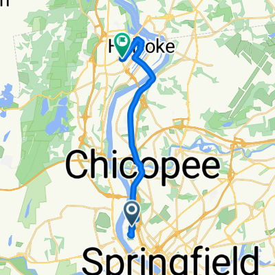
Overview
About this route
R2R11 - Bike Route - 2023
- -:--
- Duration
- 109.2 km
- Distance
- 836 m
- Ascent
- 834 m
- Descent
- ---
- Avg. speed
- 128 m
- Max. altitude

Route quality
Waytypes & surfaces along the route
Waytypes
Busy road
37.6 km
(34 %)
Quiet road
32.2 km
(29 %)
Surfaces
Paved
25.6 km
(23 %)
Unpaved
0.8 km
(<1 %)
Asphalt
20.3 km
(19 %)
Paved (undefined)
5.2 km
(5 %)
Continue with Bikemap
Use, edit, or download this cycling route
You would like to ride Ride-to-Remember XI - 2023 or customize it for your own trip? Here is what you can do with this Bikemap route:
Free features
- Save this route as favorite or in collections
- Copy & plan your own version of this route
- Split it into stages to create a multi-day tour
- Sync your route with Garmin or Wahoo
Premium features
Free trial for 3 days, or one-time payment. More about Bikemap Premium.
- Navigate this route on iOS & Android
- Export a GPX / KML file of this route
- Create your custom printout (try it for free)
- Download this route for offline navigation
Discover more Premium features.
Get Bikemap PremiumFrom our community
Other popular routes starting in West Springfield
 Waterville Lane 37, West Springfield to Dwight Street 24, Agawam
- Distance
- 10.3 km
- Ascent
- 401 m
- Descent
- 418 m
- Location
- West Springfield, Massachusetts, United States
 Restful route in West Springfield
- Distance
- 4.1 km
- Ascent
- 79 m
- Descent
- 81 m
- Location
- West Springfield, Massachusetts, United States
 work + random biking
- Distance
- 16.9 km
- Ascent
- 53 m
- Descent
- 53 m
- Location
- West Springfield, Massachusetts, United States
 Ride-to-Remember XI - 2023
- Distance
- 109.2 km
- Ascent
- 836 m
- Descent
- 834 m
- Location
- West Springfield, Massachusetts, United States
 Lowell Ave to River Rd
- Distance
- 6.3 km
- Ascent
- 18 m
- Descent
- 18 m
- Location
- West Springfield, Massachusetts, United States
 Talcott Ave, Springfield to Beech St, Holyoke
- Distance
- 14.6 km
- Ascent
- 120 m
- Descent
- 79 m
- Location
- West Springfield, Massachusetts, United States
 Recovered Route
- Distance
- 4.5 km
- Ascent
- 29 m
- Descent
- 56 m
- Location
- West Springfield, Massachusetts, United States
 Summer Street 20, Agawam to North Street 428
- Distance
- 3.1 km
- Ascent
- 36 m
- Descent
- 8 m
- Location
- West Springfield, Massachusetts, United States
Open it in the app