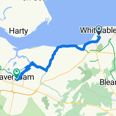
Old Farm Close 6 to Hicks Forstal Road
A cycling route starting in Whitstable, England, United Kingdom.
Overview
About this route
- 48 min
- Duration
- 11.6 km
- Distance
- 77 m
- Ascent
- 84 m
- Descent
- 14.4 km/h
- Avg. speed
- 73 m
- Max. altitude
Route quality
Waytypes & surfaces along the route
Waytypes
Track
4.9 km
(42 %)
Cycleway
3.4 km
(29 %)
Surfaces
Paved
4.2 km
(36 %)
Unpaved
5.6 km
(48 %)
Asphalt
4.2 km
(36 %)
Gravel
4 km
(34 %)
Continue with Bikemap
Use, edit, or download this cycling route
You would like to ride Old Farm Close 6 to Hicks Forstal Road or customize it for your own trip? Here is what you can do with this Bikemap route:
Free features
- Save this route as favorite or in collections
- Copy & plan your own version of this route
- Sync your route with Garmin or Wahoo
Premium features
Free trial for 3 days, or one-time payment. More about Bikemap Premium.
- Navigate this route on iOS & Android
- Export a GPX / KML file of this route
- Create your custom printout (try it for free)
- Download this route for offline navigation
Discover more Premium features.
Get Bikemap PremiumFrom our community
Other popular routes starting in Whitstable
- Faversham Road 28, Seasalter to Island Wall 2
- Distance
- 102.6 km
- Ascent
- 387 m
- Descent
- 393 m
- Location
- Whitstable, England, United Kingdom
- Linnet Avenue 7 to Linnet Avenue 13
- Distance
- 50.8 km
- Ascent
- 391 m
- Descent
- 392 m
- Location
- Whitstable, England, United Kingdom
- Viking Bay
- Distance
- 78.5 km
- Ascent
- 179 m
- Descent
- 169 m
- Location
- Whitstable, England, United Kingdom
- Freewheel - Rodmersham
- Distance
- 48.2 km
- Ascent
- 241 m
- Descent
- 241 m
- Location
- Whitstable, England, United Kingdom
- Seasalter Lane 96 to Harbour Parade 54
- Distance
- 55 km
- Ascent
- 28 m
- Descent
- 75 m
- Location
- Whitstable, England, United Kingdom
- Canterbury and Stodmarsh
- Distance
- 50.7 km
- Ascent
- 271 m
- Descent
- 271 m
- Location
- Whitstable, England, United Kingdom
- Oxford Street to High Street
- Distance
- 39.3 km
- Ascent
- 222 m
- Descent
- 206 m
- Location
- Whitstable, England, United Kingdom
- whit cant
- Distance
- 38.8 km
- Ascent
- 271 m
- Descent
- 272 m
- Location
- Whitstable, England, United Kingdom
Open it in the app