
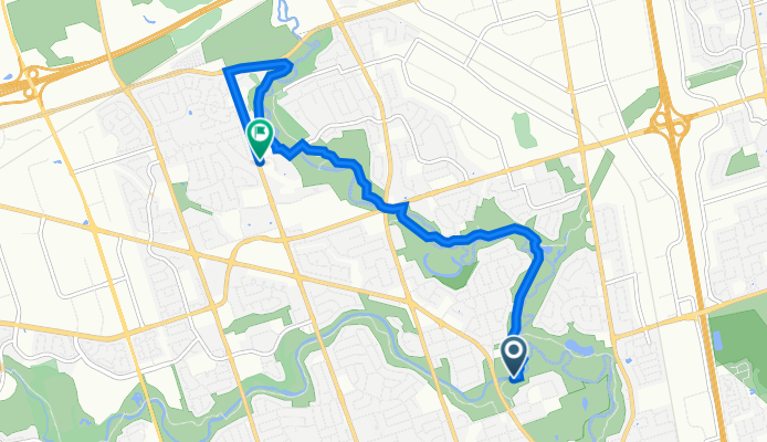
Tandridge Crescent 16, Toronto to Rowntree Road 520, Toronto
A cycling route starting in Etobicoke, Ontario, Canada.
Overview
About this route
- 44 min
- Duration
- 8.1 km
- Distance
- 91 m
- Ascent
- 63 m
- Descent
- 11.2 km/h
- Avg. speed
- 176 m
- Max. altitude
Route quality
Waytypes & surfaces along the route
Waytypes
Cycleway
3.3 km
(40 %)
Path
2.8 km
(35 %)
Surfaces
Paved
7.9 km
(97 %)
Unpaved
0.1 km
(2 %)
Asphalt
7 km
(86 %)
Concrete
0.7 km
(9 %)
Continue with Bikemap
Use, edit, or download this cycling route
You would like to ride Tandridge Crescent 16, Toronto to Rowntree Road 520, Toronto or customize it for your own trip? Here is what you can do with this Bikemap route:
Free features
- Save this route as favorite or in collections
- Copy & plan your own version of this route
- Sync your route with Garmin or Wahoo
Premium features
Free trial for 3 days, or one-time payment. More about Bikemap Premium.
- Navigate this route on iOS & Android
- Export a GPX / KML file of this route
- Create your custom printout (try it for free)
- Download this route for offline navigation
Discover more Premium features.
Get Bikemap PremiumFrom our community
Other popular routes starting in Etobicoke
 Easy ride in Mississauga
- Distance
- 13.7 km
- Ascent
- 33 m
- Descent
- 12 m
- Location
- Etobicoke, Ontario, Canada
 Blistering ride in Toronto
- Distance
- 32.6 km
- Ascent
- 170 m
- Descent
- 169 m
- Location
- Etobicoke, Ontario, Canada
 Relaxed route in Toronto
- Distance
- 16.9 km
- Ascent
- 0 m
- Descent
- 0 m
- Location
- Etobicoke, Ontario, Canada
 OLD STREET ROUTE
- Distance
- 17.9 km
- Ascent
- 80 m
- Descent
- 81 m
- Location
- Etobicoke, Ontario, Canada
 bolton Kleinberg Loop
- Distance
- 78.2 km
- Ascent
- 244 m
- Descent
- 244 m
- Location
- Etobicoke, Ontario, Canada
 Distilery
- Distance
- 24.9 km
- Ascent
- 84 m
- Descent
- 146 m
- Location
- Etobicoke, Ontario, Canada
 Malton GO to Union Via West Humber River Trial and High Park Zoo
- Distance
- 43.5 km
- Ascent
- 285 m
- Descent
- 366 m
- Location
- Etobicoke, Ontario, Canada
 Old Mill Return Via Humber River, Duck Pond, Centennial Park Conservatory, Etobicoke Creek, Lakeshore
- Distance
- 39.8 km
- Ascent
- 320 m
- Descent
- 303 m
- Location
- Etobicoke, Ontario, Canada
Open it in the app