

MeHC 2023
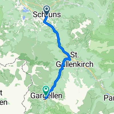
A cycling route starting in Schruns, Vorarlberg, Austria.
Overview
About this route
- -:--
- Duration
- 9.9 km
- Distance
- 1,174 m
- Ascent
- 6 m
- Descent
- ---
- Avg. speed
- 1,857 m
- Max. altitude

Route quality
Waytypes & surfaces along the route
Waytypes
Track
6.1 km
(62 %)
Quiet road
3.5 km
(35 %)
Surfaces
Paved
3.8 km
(38 %)
Unpaved
6.1 km
(62 %)
Gravel
5 km
(51 %)
Asphalt
3.7 km
(37 %)
Route highlights
Points of interest along the route
Drinking water after 5.1 km
TAZ 10
Continue with Bikemap
Use, edit, or download this cycling route
You would like to ride MeHC 2023 or customize it for your own trip? Here is what you can do with this Bikemap route:
Free features
- Save this route as favorite or in collections
- Copy & plan your own version of this route
- Sync your route with Garmin or Wahoo
Premium features
Free trial for 3 days, or one-time payment. More about Bikemap Premium.
- Navigate this route on iOS & Android
- Export a GPX / KML file of this route
- Create your custom printout (try it for free)
- Download this route for offline navigation
Discover more Premium features.
Get Bikemap PremiumFrom our community
Other popular routes starting in Schruns
 2023_Seeradler_Schruns_04
- Distance
- 64 km
- Ascent
- 1,960 m
- Descent
- 1,959 m
- Location
- Schruns, Vorarlberg, Austria
 2011_2_Vorarlberg-Tirol-Allgäu-Runde (BAFGOR)_Tschagguns - See
- Distance
- 74.9 km
- Ascent
- 1,398 m
- Descent
- 1,068 m
- Location
- Schruns, Vorarlberg, Austria
 2023_Seeradler_Schruns_03
- Distance
- 15.2 km
- Ascent
- 1,728 m
- Descent
- 103 m
- Location
- Schruns, Vorarlberg, Austria
 Bike & Hike Muttjöchle (E-Bike)
- Distance
- 40 km
- Ascent
- 1,422 m
- Descent
- 1,422 m
- Location
- Schruns, Vorarlberg, Austria
 Rund um den Itonskopf Tour
- Distance
- 24.4 km
- Ascent
- 1,319 m
- Descent
- 916 m
- Location
- Schruns, Vorarlberg, Austria
 MeHC 2023
- Distance
- 9.9 km
- Ascent
- 1,174 m
- Descent
- 6 m
- Location
- Schruns, Vorarlberg, Austria
 Montafon Mountainbike Marathon M2 - anspruchsvoll
- Distance
- 64.5 km
- Ascent
- 2,149 m
- Descent
- 2,149 m
- Location
- Schruns, Vorarlberg, Austria
 Schruns nach Gargellen 1
- Distance
- 17.4 km
- Ascent
- 956 m
- Descent
- 204 m
- Location
- Schruns, Vorarlberg, Austria
Open it in the app