

Radurlaub_2023
Großkirchheim- Obertilliach
A cycling route starting in Großkirchheim, Carinthia, Austria.
Overview
About this route
Gefahren am 5. Juni 2023
Das Wetter wird rechtzeitig besser. Es geht den wunderbaren R8 bergab bis Winklern, und der B107 entlang über den Iselsberg - Dölsach zum Drauradweg. Der Drauradweg bis Tassenbach ist wiederum ein totaler Genuss. Sehr schön angelegt, abseits der B100. Mit stetigen und leichten Anstiegen sind die Höhenmeter auch mit mehr Ausrüstung leicht zu bewältigen.
Ab Tassenbach geht's über den Kartitschsattel nach Obertillian. Im Mangel an Alternativen ist die B111 genutzt worden. Landschaftlich wirklich sehr schön, der mot. Verkehr muss in diesem Fall ausgeblendet werden.
- -:--
- Duration
- 76.6 km
- Distance
- 1,558 m
- Ascent
- 1,146 m
- Descent
- ---
- Avg. speed
- 1,532 m
- Max. altitude

Part of
6 stages
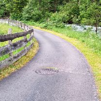
Route photos


Route quality
Waytypes & surfaces along the route
Waytypes
Busy road
23.2 km
(30 %)
Cycleway
21.3 km
(28 %)
Surfaces
Paved
68.8 km
(90 %)
Unpaved
0.7 km
(<1 %)
Asphalt
66.5 km
(87 %)
Paved (undefined)
2 km
(3 %)
Continue with Bikemap
Use, edit, or download this cycling route
You would like to ride Großkirchheim- Obertilliach or customize it for your own trip? Here is what you can do with this Bikemap route:
Free features
- Save this route as favorite or in collections
- Copy & plan your own version of this route
- Sync your route with Garmin or Wahoo
Premium features
Free trial for 3 days, or one-time payment. More about Bikemap Premium.
- Navigate this route on iOS & Android
- Export a GPX / KML file of this route
- Create your custom printout (try it for free)
- Download this route for offline navigation
Discover more Premium features.
Get Bikemap PremiumFrom our community
Other popular routes starting in Großkirchheim
 Döllach FJHöhe Edelweißspitze Döllach
- Distance
- 83.4 km
- Ascent
- 2,655 m
- Descent
- 2,653 m
- Location
- Großkirchheim, Carinthia, Austria
 Großkirchheim- Obertilliach
- Distance
- 76.6 km
- Ascent
- 1,558 m
- Descent
- 1,146 m
- Location
- Großkirchheim, Carinthia, Austria
 Döllach-Franz Josef Höhe
- Distance
- 31.2 km
- Ascent
- 1,727 m
- Descent
- 564 m
- Location
- Großkirchheim, Carinthia, Austria
 p16 Przełęcz Hochtor / Großglocknerstraße
- Distance
- 57.3 km
- Ascent
- 1,735 m
- Descent
- 1,997 m
- Location
- Großkirchheim, Carinthia, Austria
 Transalp 2.Tag RL bis Corvara
- Distance
- 154.5 km
- Ascent
- 2,447 m
- Descent
- 1,839 m
- Location
- Großkirchheim, Carinthia, Austria
 Döllach - Heiligenblut - Kasereck
- Distance
- 20.5 km
- Ascent
- 954 m
- Descent
- 137 m
- Location
- Großkirchheim, Carinthia, Austria
 6.Deň
6.Deň- Distance
- 86 km
- Ascent
- 2,379 m
- Descent
- 2,698 m
- Location
- Großkirchheim, Carinthia, Austria
 Döllach - Asten
- Distance
- 29.5 km
- Ascent
- 1,456 m
- Descent
- 1,456 m
- Location
- Großkirchheim, Carinthia, Austria
Open it in the app