
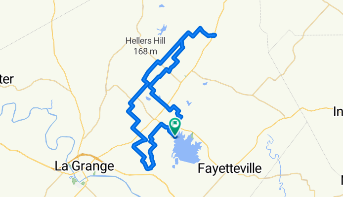
Park Prairie Park Top
A cycling route starting in La Grange, Texas, United States.
Overview
About this route
- 4 h 13 min
- Duration
- 68.2 km
- Distance
- 460 m
- Ascent
- 464 m
- Descent
- 16.2 km/h
- Avg. speed
- 168 m
- Max. altitude
Route quality
Waytypes & surfaces along the route
Waytypes
Quiet road
66 km
(97 %)
Busy road
2.2 km
(3 %)
Surfaces
Paved
3.4 km
(5 %)
Unpaved
0.9 km
(1 %)
Asphalt
3.4 km
(5 %)
Gravel
0.9 km
(1 %)
Undefined
64 km
(94 %)
Continue with Bikemap
Use, edit, or download this cycling route
You would like to ride Park Prairie Park Top or customize it for your own trip? Here is what you can do with this Bikemap route:
Free features
- Save this route as favorite or in collections
- Copy & plan your own version of this route
- Sync your route with Garmin or Wahoo
Premium features
Free trial for 3 days, or one-time payment. More about Bikemap Premium.
- Navigate this route on iOS & Android
- Export a GPX / KML file of this route
- Create your custom printout (try it for free)
- Download this route for offline navigation
Discover more Premium features.
Get Bikemap PremiumFrom our community
Other popular routes starting in La Grange
 Hill Ride!
- Distance
- 33.7 km
- Ascent
- 243 m
- Descent
- 243 m
- Location
- La Grange, Texas, United States
 monument hill
- Distance
- 20.5 km
- Ascent
- 103 m
- Descent
- 119 m
- Location
- La Grange, Texas, United States
 David's Small Roads-Only Roundtop Loop
- Distance
- 39.7 km
- Ascent
- 194 m
- Descent
- 195 m
- Location
- La Grange, Texas, United States
 North Jefferson Street 401, La Grange to North Jefferson Street 401, La Grange
- Distance
- 2.1 km
- Ascent
- 11 m
- Descent
- 3 m
- Location
- La Grange, Texas, United States
 La Grange hills!
- Distance
- 32.9 km
- Ascent
- 152 m
- Descent
- 149 m
- Location
- La Grange, Texas, United States
 Day 2: La Grange -- College Station Option 2 - 78mi
- Distance
- 125.7 km
- Ascent
- 628 m
- Descent
- 631 m
- Location
- La Grange, Texas, United States
 La Grange Hills On The Specialized Rockhopper Sport 29er.
- Distance
- 27.8 km
- Ascent
- 189 m
- Descent
- 191 m
- Location
- La Grange, Texas, United States
 Reba's Deli & Pizzeria for lunch.
- Distance
- 3.3 km
- Ascent
- 4 m
- Descent
- 4 m
- Location
- La Grange, Texas, United States
Open it in the app