

Staza smeća i užasa
A cycling route starting in Novi Vinodolski, Primorje-Gorski Kotar County, Croatia.
Overview
About this route
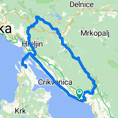
This is a short trail. It is called the garbage trail because the first section after descending from the road is full of trash from the nearby landfill, and the horror comes later when the trail becomes so difficult that it is a problem to push the bike, let alone ride. The first 5 km are on the road with a constant incline of about 5%. We turn towards Fužine, Lič, and Bribir and after about 300 m we leave the road (there are signs on the trees and the road). First, we descend down a gentle slope over rocky ground. After a few hundred meters, the terrain becomes rockier and starts to sink into the surrounding land. The rocks get bigger and it is almost impossible to ride the next few hundred meters. After that, the trail sharply turns into the woods and this is the best part because it is no longer rocky. The section through the woods is short and leads us to a local gravel road. We turn right and ride straight on the gravel. We ascend the gravel into the city and then we ride again on asphalt.
- -:--
- Duration
- 9 km
- Distance
- 343 m
- Ascent
- 343 m
- Descent
- ---
- Avg. speed
- ---
- Max. altitude

Route highlights
Points of interest along the route

Photo after 6.3 km
Rocky part a little later

Photo after 6.5 km
Rocky part
Continue with Bikemap
Use, edit, or download this cycling route
You would like to ride Staza smeća i užasa or customize it for your own trip? Here is what you can do with this Bikemap route:
Free features
- Save this route as favorite or in collections
- Copy & plan your own version of this route
- Sync your route with Garmin or Wahoo
Premium features
Free trial for 3 days, or one-time payment. More about Bikemap Premium.
- Navigate this route on iOS & Android
- Export a GPX / KML file of this route
- Create your custom printout (try it for free)
- Download this route for offline navigation
Discover more Premium features.
Get Bikemap PremiumFrom our community
Other popular routes starting in Novi Vinodolski
 104 km/1700vm - Tura za 1. dan
- Distance
- 104.3 km
- Ascent
- 1,380 m
- Descent
- 1,378 m
- Location
- Novi Vinodolski, Primorje-Gorski Kotar County, Croatia
 Klenovica_Hrib_Okolica
- Distance
- 38.3 km
- Ascent
- 854 m
- Descent
- 858 m
- Location
- Novi Vinodolski, Primorje-Gorski Kotar County, Croatia
 2. Tag: Novi Vinodolski - Pag
- Distance
- 111.2 km
- Ascent
- 1,003 m
- Descent
- 1,049 m
- Location
- Novi Vinodolski, Primorje-Gorski Kotar County, Croatia
 Klenovica Große Abendrunde
- Distance
- 32.2 km
- Ascent
- 852 m
- Descent
- 853 m
- Location
- Novi Vinodolski, Primorje-Gorski Kotar County, Croatia
 41 km Flow Backcountry
- Distance
- 40.9 km
- Ascent
- 1,240 m
- Descent
- 1,209 m
- Location
- Novi Vinodolski, Primorje-Gorski Kotar County, Croatia
 Novi-Fuzine
- Distance
- 71.4 km
- Ascent
- 1,222 m
- Descent
- 1,222 m
- Location
- Novi Vinodolski, Primorje-Gorski Kotar County, Croatia
 Počitniška enota Klenovica, Smokvica Krmpotska to Ulica Grabići 19, Klenovica
- Distance
- 16.2 km
- Ascent
- 386 m
- Descent
- 406 m
- Location
- Novi Vinodolski, Primorje-Gorski Kotar County, Croatia
 Povile – Prizna / 23-10-2013
- Distance
- 70.7 km
- Ascent
- 966 m
- Descent
- 689 m
- Location
- Novi Vinodolski, Primorje-Gorski Kotar County, Croatia
Open it in the app