

Nantes_11MAI23
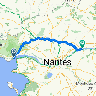
A cycling route starting in Saint-Nazaire, Pays de la Loire Region, France.
Overview
About this route
0
- -:--
- Duration
- 62.9 km
- Distance
- 126 m
- Ascent
- 105 m
- Descent
- ---
- Avg. speed
- 27 m
- Max. altitude
Peter Bopp
created this 3 years ago
Route quality
Waytypes & surfaces along the route
Waytypes
Quiet road
24.5 km
39 %
Cycleway
16.3 km
26 %
Surfaces
Paved
50.9 km
(81 %)
Unpaved
8.8 km
(14 %)
Asphalt
48.4 km
77 %
Gravel
8.8 km
14 %
Continue with Bikemap
Use, edit, or download this cycling route
You would like to ride Nantes_11MAI23 or customize it for your own trip? Here is what you can do with this Bikemap route:
Free features
- Save this route as favorite or in collections
- Copy & plan your own version of this route
- Sync your route with Garmin or Wahoo
Premium features
Free trial for 3 days, or one-time payment. More about Bikemap Premium.
- Navigate this route on iOS & Android
- Export a GPX / KML file of this route
- Create your custom printout (try it for free)
- Download this route for offline navigation
Discover more Premium features.
Get Bikemap PremiumFrom our community
Other popular routes starting in Saint-Nazaire
- De Place Pierre Semard à Place Pierre Semard0
- 151.5 km
- 392 m
- 386 m
- Saint-Nazaire, Pays de la Loire Region, France
- Von Saint-Nazaire bis Plougasnou0
- 406.5 km
- 2,879 m
- 2,871 m
- Saint-Nazaire, Pays de la Loire Region, France
- Von Saint-Nazaire bis Samstagern0
- 1,220.9 km
- 6,067 m
- 5,448 m
- Saint-Nazaire, Pays de la Loire Region, France
- Saint-Nazaire - Saint-Sébastien-sur-Loire0
- 69.3 km
- 234 m
- 234 m
- Saint-Nazaire, Pays de la Loire Region, France
- Von Saint-Nazaire bis Ancenis-Saint-Géréon0
- 113.7 km
- 332 m
- 323 m
- Saint-Nazaire, Pays de la Loire Region, France


Open it in the app