
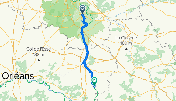
Tag 10 - BP - Fontainebleau- Chatillon-Coligny
A cycling route starting in Fontainebleau, Île-de-France Region, France.
Overview
About this route
- -:--
- Duration
- 80.7 km
- Distance
- 348 m
- Ascent
- 314 m
- Descent
- ---
- Avg. speed
- 126 m
- Max. altitude

Route quality
Waytypes & surfaces along the route
Waytypes
Cycleway
30.5 km
(38 %)
Path
22.6 km
(28 %)
Surfaces
Paved
43.6 km
(54 %)
Unpaved
18.5 km
(23 %)
Asphalt
43.4 km
(54 %)
Gravel
18.2 km
(23 %)
Continue with Bikemap
Use, edit, or download this cycling route
You would like to ride Tag 10 - BP - Fontainebleau- Chatillon-Coligny or customize it for your own trip? Here is what you can do with this Bikemap route:
Free features
- Save this route as favorite or in collections
- Copy & plan your own version of this route
- Split it into stages to create a multi-day tour
- Sync your route with Garmin or Wahoo
Premium features
Free trial for 3 days, or one-time payment. More about Bikemap Premium.
- Navigate this route on iOS & Android
- Export a GPX / KML file of this route
- Create your custom printout (try it for free)
- Download this route for offline navigation
Discover more Premium features.
Get Bikemap PremiumFrom our community
Other popular routes starting in Fontainebleau
 Fontainebleu
- Distance
- 29.6 km
- Ascent
- 217 m
- Descent
- 217 m
- Location
- Fontainebleau, Île-de-France Region, France
 bouldering part 2
- Distance
- 8.4 km
- Ascent
- 105 m
- Descent
- 84 m
- Location
- Fontainebleau, Île-de-France Region, France
 Le Loing
- Distance
- 120 km
- Ascent
- 188 m
- Descent
- 155 m
- Location
- Fontainebleau, Île-de-France Region, France
 Etape 11: Bourgogne
- Distance
- 80.1 km
- Ascent
- 196 m
- Descent
- 232 m
- Location
- Fontainebleau, Île-de-France Region, France
 Fontainebleau - Paris
- Distance
- 71.9 km
- Ascent
- 245 m
- Descent
- 267 m
- Location
- Fontainebleau, Île-de-France Region, France
 Fontainebleau
- Distance
- 4.1 km
- Ascent
- 38 m
- Descent
- 38 m
- Location
- Fontainebleau, Île-de-France Region, France
 La Grotte de Beatrix - Fontainebleau
- Distance
- 25.5 km
- Ascent
- 288 m
- Descent
- 288 m
- Location
- Fontainebleau, Île-de-France Region, France
 entre mont aigu apremont et franchard
- Distance
- 29.7 km
- Ascent
- 217 m
- Descent
- 217 m
- Location
- Fontainebleau, Île-de-France Region, France
Open it in the app