

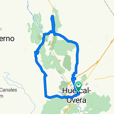
Huercal Overa-Tetica de Bacares. 4550m en 171,3km con 3700m en 110km
A cycling route starting in Huercal Overa, Andalusia, Spain.
Overview
About this route
Link 61.0 km (+890/-400)
C Alto 27.2 km 5.2% 1423 m km 88.2 2158 m
Descent 28.1 km link 6.1 km
C Alto 19.3 km 6.4% 1239 m km 141.7 1973 m
Descent 14.0 km
T Bacares 15.6 km 5.6% 867 m km 171.3 2051 m
Loop 56.7 km from km 85 to km 141.7
- -:--
- Duration
- 171.3 km
- Distance
- 5,324 m
- Ascent
- 3,517 m
- Descent
- ---
- Avg. speed
- 2,163 m
- Max. altitude
Route quality
Waytypes & surfaces along the route
Waytypes
Road
114.8 km
(67 %)
Quiet road
17.1 km
(10 %)
Surfaces
Paved
85.7 km
(50 %)
Unpaved
1.7 km
(1 %)
Asphalt
85.7 km
(50 %)
Gravel
1.7 km
(1 %)
Undefined
83.9 km
(49 %)
Continue with Bikemap
Use, edit, or download this cycling route
You would like to ride Huercal Overa-Tetica de Bacares. 4550m en 171,3km con 3700m en 110km or customize it for your own trip? Here is what you can do with this Bikemap route:
Free features
- Save this route as favorite or in collections
- Copy & plan your own version of this route
- Split it into stages to create a multi-day tour
- Sync your route with Garmin or Wahoo
Premium features
Free trial for 3 days, or one-time payment. More about Bikemap Premium.
- Navigate this route on iOS & Android
- Export a GPX / KML file of this route
- Create your custom printout (try it for free)
- Download this route for offline navigation
Discover more Premium features.
Get Bikemap PremiumFrom our community
Other popular routes starting in Huercal Overa
 Alicante - Huércal-Overa
- Distance
- 203.8 km
- Ascent
- 395 m
- Descent
- 686 m
- Location
- Huercal Overa, Andalusia, Spain
 RUTA ESTANCO Nº3 HUÉRCAL-OVERA
- Distance
- 67.3 km
- Ascent
- 531 m
- Descent
- 527 m
- Location
- Huercal Overa, Andalusia, Spain
 Giviley-El perellon-La Hoya-Almajalejo
- Distance
- 37.9 km
- Ascent
- 519 m
- Descent
- 478 m
- Location
- Huercal Overa, Andalusia, Spain
 Huercal-Overa_Taberno
- Distance
- 34.4 km
- Ascent
- 468 m
- Descent
- 468 m
- Location
- Huercal Overa, Andalusia, Spain
 Huércal-Overa to Avenida de la Virgen de la Salud, Zurgena
- Distance
- 18.9 km
- Ascent
- 215 m
- Descent
- 252 m
- Location
- Huercal Overa, Andalusia, Spain
 Huercal Overa-Tetica de Bacares. 4550m en 171,3km con 3700m en 110km
- Distance
- 171.3 km
- Ascent
- 5,324 m
- Descent
- 3,517 m
- Location
- Huercal Overa, Andalusia, Spain
 Up to Cazorla on road
- Distance
- 179.1 km
- Ascent
- 1,899 m
- Descent
- 1,382 m
- Location
- Huercal Overa, Andalusia, Spain
 De Calle Cementerio a Calle Santa Maria de Nieva
- Distance
- 3.9 km
- Ascent
- 101 m
- Descent
- 90 m
- Location
- Huercal Overa, Andalusia, Spain
Open it in the app