

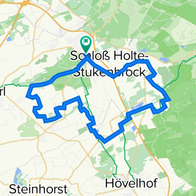
MTB zum Hermannsdenkmal
A cycling route starting in Oerlinghausen, North Rhine-Westphalia, Germany.
Overview
About this route
leichte MTB-Tour von
Schloß Holte zum Hermannsdenkmal
-
Anfahrt Asphalt, ab Segelflugplatz Schotter und Wald
-
Abfahrt vom Hermannsdenkmal über die Straße zum unteren Parkplatz
Auf dem Hinweg wird das Waldlokal "Bienenschmidt" passiert, im Sommer die Tour rückwärts fahren und zum Schluss auf ein "Hefe" einkehren ;-)
- -:--
- Duration
- 48.1 km
- Distance
- 612 m
- Ascent
- 571 m
- Descent
- ---
- Avg. speed
- 384 m
- Max. altitude
Route quality
Waytypes & surfaces along the route
Waytypes
Track
19.8 km
(41 %)
Quiet road
13.7 km
(28 %)
Surfaces
Paved
19.2 km
(40 %)
Unpaved
23.4 km
(49 %)
Asphalt
17.7 km
(37 %)
Gravel
14.8 km
(31 %)
Continue with Bikemap
Use, edit, or download this cycling route
You would like to ride MTB zum Hermannsdenkmal or customize it for your own trip? Here is what you can do with this Bikemap route:
Free features
- Save this route as favorite or in collections
- Copy & plan your own version of this route
- Sync your route with Garmin or Wahoo
Premium features
Free trial for 3 days, or one-time payment. More about Bikemap Premium.
- Navigate this route on iOS & Android
- Export a GPX / KML file of this route
- Create your custom printout (try it for free)
- Download this route for offline navigation
Discover more Premium features.
Get Bikemap PremiumFrom our community
Other popular routes starting in Oerlinghausen
 Tönsberg bis Teiche
- Distance
- 25.5 km
- Ascent
- 508 m
- Descent
- 515 m
- Location
- Oerlinghausen, North Rhine-Westphalia, Germany
 Route von Moselweg Bielefeld-Sennestadt nach Eiffelturm Avenue Gustave Eiffel Paris Frankreich-LINESTRING - Route von Moselweg, Bielefeld-Sennestadt nach Eif...
- Distance
- 1,450.3 km
- Ascent
- 6,049 m
- Descent
- 6,177 m
- Location
- Oerlinghausen, North Rhine-Westphalia, Germany
 Leopoldshöhe>Steinhorster Becken
- Distance
- 72.6 km
- Ascent
- 275 m
- Descent
- 254 m
- Location
- Oerlinghausen, North Rhine-Westphalia, Germany
 Schloß Holte - Herrmansdenkmal
- Distance
- 44.2 km
- Ascent
- 562 m
- Descent
- 520 m
- Location
- Oerlinghausen, North Rhine-Westphalia, Germany
 Von Schloss Holte zur Sparrenburg (Hermannsweg)
- Distance
- 24.3 km
- Ascent
- 415 m
- Descent
- 373 m
- Location
- Oerlinghausen, North Rhine-Westphalia, Germany
 Durch den Sand der Senne - Hermannshöhen Tourentipp 11
- Distance
- 20.7 km
- Ascent
- 516 m
- Descent
- 514 m
- Location
- Oerlinghausen, North Rhine-Westphalia, Germany
 Schl. Holte Sennebäche
- Distance
- 36.3 km
- Ascent
- 90 m
- Descent
- 92 m
- Location
- Oerlinghausen, North Rhine-Westphalia, Germany
 Oerlinghausen-Hermannsdenkmal
- Distance
- 34.5 km
- Ascent
- 674 m
- Descent
- 674 m
- Location
- Oerlinghausen, North Rhine-Westphalia, Germany
Open it in the app