
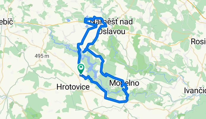
těžší vytrvalostní Dalešice -Mohelno -Hartvikovice-Náměšť n. Oslavou-Dalešice
A cycling route starting in Hrotovice, Kraj Vysočina, Czechia.
Overview
About this route
Trasa je většinoui po silnici s vyšším provozem jinak vede po polních cestách vede kolem zajímavých přírodních památek jako jsou Mohelnská Hadcova step,Wilsonova skála.Dále jsou po cestě dvě rozhledny Babylon u Kramolína a Ocmanická rozhledna u vodojemu
- -:--
- Duration
- 57 km
- Distance
- 492 m
- Ascent
- 495 m
- Descent
- ---
- Avg. speed
- ---
- Max. altitude
Continue with Bikemap
Use, edit, or download this cycling route
You would like to ride těžší vytrvalostní Dalešice -Mohelno -Hartvikovice-Náměšť n. Oslavou-Dalešice or customize it for your own trip? Here is what you can do with this Bikemap route:
Free features
- Save this route as favorite or in collections
- Copy & plan your own version of this route
- Sync your route with Garmin or Wahoo
Premium features
Free trial for 3 days, or one-time payment. More about Bikemap Premium.
- Navigate this route on iOS & Android
- Export a GPX / KML file of this route
- Create your custom printout (try it for free)
- Download this route for offline navigation
Discover more Premium features.
Get Bikemap PremiumFrom our community
Other popular routes starting in Hrotovice
 Etappe 2 Wien- Berlin
- Distance
- 121.6 km
- Ascent
- 830 m
- Descent
- 751 m
- Location
- Hrotovice, Kraj Vysočina, Czechia
 Morawy Południowe_3
- Distance
- 38.8 km
- Ascent
- 286 m
- Descent
- 462 m
- Location
- Hrotovice, Kraj Vysočina, Czechia
 Lehká,trasa Hrotovickem
- Distance
- 23.9 km
- Ascent
- 160 m
- Descent
- 158 m
- Location
- Hrotovice, Kraj Vysočina, Czechia
 Dalešice - Třebíč - Dalešice
- Distance
- 53.3 km
- Ascent
- 332 m
- Descent
- 331 m
- Location
- Hrotovice, Kraj Vysočina, Czechia
 Dalešický Šlapák 2012 - zpět
- Distance
- 50.5 km
- Ascent
- 406 m
- Descent
- 538 m
- Location
- Hrotovice, Kraj Vysočina, Czechia
 Dalesice - Brno - 70 km
- Distance
- 69.6 km
- Ascent
- 532 m
- Descent
- 686 m
- Location
- Hrotovice, Kraj Vysočina, Czechia
 2019-08-18
- Distance
- 45.5 km
- Ascent
- 1,193 m
- Descent
- 1,178 m
- Location
- Hrotovice, Kraj Vysočina, Czechia
 Dalešice - Ketkovice
- Distance
- 25.6 km
- Ascent
- 332 m
- Descent
- 300 m
- Location
- Hrotovice, Kraj Vysočina, Czechia
Open it in the app