- 97.3 km
- 1,212 m
- 1,316 m
- Eslarn, Bavaria, Germany
2011 Eslarn Bocklradweg-Schwarzachtal Neunburg
A cycling route starting in Eslarn, Bavaria, Germany.
Overview
About this route
crossing through the nothingness of the Oberpfalz
only lonely forests and tiny bugs
great area
in terms of elevation, it was fine
the Schwarzachtal cycle path also follows an old railway line
by the lake, quite a steep field where there is no railway line
but a beautiful corner
- -:--
- Duration
- 55 km
- Distance
- 349 m
- Ascent
- 478 m
- Descent
- ---
- Avg. speed
- ---
- Max. altitude
created this 14 years ago
Route highlights
Points of interest along the route
Point of interest after 9.5 km
touri info zum goldabbau an diesem hügel
Point of interest after 22.7 km
mittagspause wieder ma über 30 grad
Point of interest after 30.5 km
brunnen
Point of interest after 30.6 km
kaffeepause
Point of interest after 34.3 km
Beginn schwarzachtalradweg...auch ne alte bahnlinie
Point of interest after 38 km
museum und kaffeepause
Point of interest after 38.6 km
hängemattenpause bei wiedermal 35 grad
Point of interest after 45.9 km
der abschnitt ist eher mountainbike geeignet! schieben...keine chance
Point of interest after 55 km
Continue with Bikemap
Use, edit, or download this cycling route
You would like to ride 2011 Eslarn Bocklradweg-Schwarzachtal Neunburg or customize it for your own trip? Here is what you can do with this Bikemap route:
Free features
- Save this route as favorite or in collections
- Copy & plan your own version of this route
- Sync your route with Garmin or Wahoo
Premium features
Free trial for 3 days, or one-time payment. More about Bikemap Premium.
- Navigate this route on iOS & Android
- Export a GPX / KML file of this route
- Create your custom printout (try it for free)
- Download this route for offline navigation
Discover more Premium features.
Get Bikemap PremiumFrom our community
Other popular routes starting in Eslarn
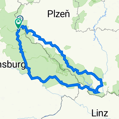
- Radtour 2025 - Etappe 3
- Eslarn - Schönsee - Oberviechtach - Nabburg - Weiden
- 96.4 km
- 418 m
- 529 m
- Eslarn, Bavaria, Germany
- Relaxed route in Eslarn
- 15.3 km
- 459 m
- 460 m
- Eslarn, Bavaria, Germany
- B/D Eslarn - Neustadt an der Waldnaab
- 50.5 km
- 439 m
- 541 m
- Eslarn, Bavaria, Germany
- Eslarn_Bela
- 42.7 km
- 953 m
- 1,032 m
- Eslarn, Bavaria, Germany
- bayrischer wald '24
- 502.1 km
- 7,231 m
- 7,094 m
- Eslarn, Bavaria, Germany
- bayrischer wald
- 502.7 km
- 7,231 m
- 7,094 m
- Eslarn, Bavaria, Germany
- Runde 1
- 93.4 km
- 1,067 m
- 1,069 m
- Eslarn, Bavaria, Germany
Open it in the app


