

Moab to Mineral Bottom Road
A cycling route starting in Moab, Utah, United States.
Overview
About this route
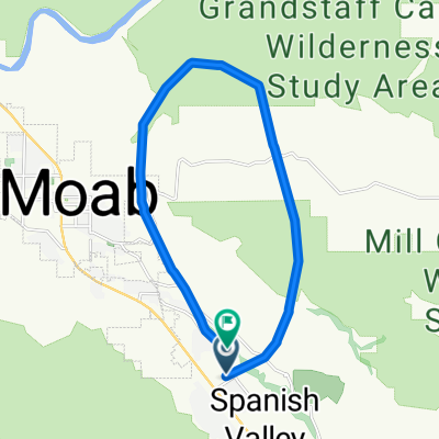
Moab to Mineral Bottom Road is a safe, fun ride that follows the bike path to highway 313.
The Bike path, which is caught just north of Moab on the north side of the Colorado River, is new and in excellent shape. You follow the path past Arches National Parks entrance and up the hill leading out of Moab Valley. This hill reaches a grade of perhaps 6% and takes riders away from the noisy highway. After a few miles the path comes back to the west passes under the highway (US191), continuing on past Gemini Bridges Road to Utah 313.
At this point you cross the road and head west, slowly turning to the south, on a wide highway with a good shoulder. Though 313 goes to Dead Horse State Park and Canyonlands National Park, it is not very busy. You follow it though Nine Mile Canyon as it constricts, then do a couple of steeper (7%-8%) switchbacks to reach the high plains near Moab and Monitor Buttes. Continue on with rolling, but generally climbing terrain (at a very low grade). Mineral Bottom Road is 23 miles out. Get there and reverse the route.
You will want to do this when there is minimal wind... it blows hard above the switchbacks on 313. Take lots of water as there are no facilities. The total is 46 miles with about 2,300 feet of climbing. If you are just visiting and don't have a bike, Poison Spider Bicycles at the north end of Moab (on 191) has great road bikes for rent.
- -:--
- Duration
- 75.4 km
- Distance
- 688 m
- Ascent
- 690 m
- Descent
- ---
- Avg. speed
- ---
- Max. altitude
Continue with Bikemap
Use, edit, or download this cycling route
You would like to ride Moab to Mineral Bottom Road or customize it for your own trip? Here is what you can do with this Bikemap route:
Free features
- Save this route as favorite or in collections
- Copy & plan your own version of this route
- Sync your route with Garmin or Wahoo
Premium features
Free trial for 3 days, or one-time payment. More about Bikemap Premium.
- Navigate this route on iOS & Android
- Export a GPX / KML file of this route
- Create your custom printout (try it for free)
- Download this route for offline navigation
Discover more Premium features.
Get Bikemap PremiumFrom our community
Other popular routes starting in Moab
 Salt Wash-DAV
- Distance
- 11.9 km
- Ascent
- 469 m
- Descent
- 356 m
- Location
- Moab, Utah, United States
 Moab - A Pretty Flat Route to Potash
- Distance
- 66.2 km
- Ascent
- 1,097 m
- Descent
- 1,092 m
- Location
- Moab, Utah, United States
 Porcupine Rim Trail
- Distance
- 22.9 km
- Ascent
- 529 m
- Descent
- 1,054 m
- Location
- Moab, Utah, United States
 Moab Gran Fondo Loop
- Distance
- 94.5 km
- Ascent
- 1,824 m
- Descent
- 1,675 m
- Location
- Moab, Utah, United States
 Potash Road
- Distance
- 68.6 km
- Ascent
- 685 m
- Descent
- 688 m
- Location
- Moab, Utah, United States
 Moab
Moab- Distance
- 17.3 km
- Ascent
- 691 m
- Descent
- 708 m
- Location
- Moab, Utah, United States
 Moab to Mineral Bottom Road
- Distance
- 75.4 km
- Ascent
- 688 m
- Descent
- 690 m
- Location
- Moab, Utah, United States
 Moab - Runde
- Distance
- 76.8 km
- Ascent
- 1,470 m
- Descent
- 1,484 m
- Location
- Moab, Utah, United States
Open it in the app