

Moab Gran Fondo Loop
A cycling route starting in Moab, Utah, United States.
Overview
About this route
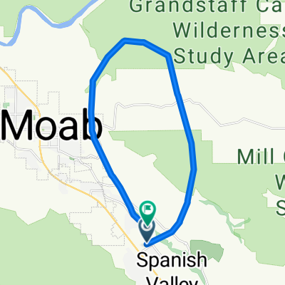
This is an incredible bike ride and a very thorough workout. The route shown ends at Old City Park but it is easy (and obvious) from this part of the Valley to complete the loop to Moab.
The route leaves Swanny Park, next to the Rec Center, at 4th North and 100 West. A 90 degree turn on to 500 West and then a left onto US191. Follow this to the next stoplight at River Road and take a right. You then follow River Road for roughly 16 miles. This is one of the most spectacular roads in the world, but sadly it has limited bike path (only to Negro Bill Canyon and the end-point of the Porcupine Rim Mtn bike route) and no shoulder or bike lane. The best way to deal with traffic, and there is quite a bit of it, is to make sure they see you. A flashing light and bright clothes are good to have as drivers are often looking at the scenery. Most locals simply ride in a manner that the drivers have to deal with them.
River Road eventually opens from the canyon to the Professor Valley. This valley, and the slightly higher Castle Valley that you will soon climb through, are as picturesque as any place in the world. Many-a John Wayne film was shot here. Keep your speed up or you might loose your scalp.
A mile or so after entering the Valley you hit your only possible turn since getting on River Road. This is a right to Castle Valley. Take it and begin a fairly steep and winding climb into the Valley. Its upwards of 8%. You crest into the valley, have a slight downhil, and then a steady 3-4% grade up through the scenery. You will pass Parriot Mesa, the Rectory, and the famous Castleton Tower (aka Castle Rock) on the left and Porcupine Rim on the right (there are mtn bikers up there looking down on you).
The road eventually enters more dense cedar forest and passes the old Castleton townsite. A sign shows you where to take a hard right as you leave the Valley and enter the La Sal mtns. This is solid climbing for the next 8 miles or so. Continue on getting a beautiful view of the desert.
Just above the Aspen Forest you will top-out. It's then rolling terrain for a few miles, followed by a descent into the Mill Creek drainage. There is a steep climb out of Mill Creek (actually at Horse Creek), then a long downhill on Brumley Ridge back into the Moab Valley.
The downhill is actually pretty technical. The road is not in the best shape, having numerous potholes and often bits of gravel. You want to make sure you are in full control as you descend. The temptation is there to let the road get you over 50 mph, but I wouldnt recommend it on your first time. Eventually you hit a big hairpin (missing it seems like it might toss you all the way into the valley). Another steep step to a second hairpin and you are down.
The road continues downhill, out of Pack Creek Canyon and past Kens Lake (Moabs Reservoir), but the steep stuff is over. Continue on through upper Moab Valley, known to locals as Spanish Valley, until you reach a stop sign at Spanish Trail (Go Straight here to get back to the Metropolis of Moab). Take a right and descend down and then over Pack Creek, then climb back up a few hundred feet. This is perhaps the hardest part of the day. Take a left at the circle and you will soon go through the finish line. A quick left onto Old City Park Rd takes you to the old City Park for the festivities.
You need a lot of water for this if you are doing it unsupported. The route is 58 miles long (64 if you go on to moab) and has 5,200 feet of climbing. Again, there are no services so bring lots of water and food. Be careful on the descents as the road has potholes. There are a few short sections that are almost just gravel in the La Sals, but its easy to deal with. Take a camera. If you wanna do this ride and don't have a road bike you can rent one at Poison Spider Bicycles.
- -:--
- Duration
- 94.5 km
- Distance
- 1,824 m
- Ascent
- 1,675 m
- Descent
- ---
- Avg. speed
- ---
- Max. altitude
Continue with Bikemap
Use, edit, or download this cycling route
You would like to ride Moab Gran Fondo Loop or customize it for your own trip? Here is what you can do with this Bikemap route:
Free features
- Save this route as favorite or in collections
- Copy & plan your own version of this route
- Split it into stages to create a multi-day tour
- Sync your route with Garmin or Wahoo
Premium features
Free trial for 3 days, or one-time payment. More about Bikemap Premium.
- Navigate this route on iOS & Android
- Export a GPX / KML file of this route
- Create your custom printout (try it for free)
- Download this route for offline navigation
Discover more Premium features.
Get Bikemap PremiumFrom our community
Other popular routes starting in Moab
 Porcupine Rim Trail
- Distance
- 22.9 km
- Ascent
- 529 m
- Descent
- 1,054 m
- Location
- Moab, Utah, United States
 Moab - A Pretty Flat Route to Potash
- Distance
- 66.2 km
- Ascent
- 1,097 m
- Descent
- 1,092 m
- Location
- Moab, Utah, United States
 Moab 100
- Distance
- 159.6 km
- Ascent
- 957 m
- Descent
- 957 m
- Location
- Moab, Utah, United States
 Moab
Moab- Distance
- 17.3 km
- Ascent
- 691 m
- Descent
- 708 m
- Location
- Moab, Utah, United States
 USA_2016_Arches-Bryce Canyon-Las Vegas
- Distance
- 924.4 km
- Ascent
- 3,861 m
- Descent
- 4,733 m
- Location
- Moab, Utah, United States
 Potash Road
- Distance
- 68.6 km
- Ascent
- 685 m
- Descent
- 688 m
- Location
- Moab, Utah, United States
 Portal Long Canyon Mag7 Portal
- Distance
- 72.7 km
- Ascent
- 1,754 m
- Descent
- 1,750 m
- Location
- Moab, Utah, United States
 Moab - Runde
- Distance
- 76.8 km
- Ascent
- 1,470 m
- Descent
- 1,484 m
- Location
- Moab, Utah, United States
Open it in the app