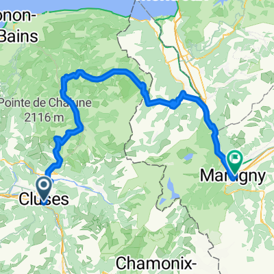
*XX-?. Cluses - Croix de Dormiaz (Km 147)
A cycling route starting in Cluses, Auvergne-Rh么ne-Alpes, France.
Overview
About this route
- -:--
- Duration
- 146.9 km
- Distance
- 5,075 m
- Ascent
- 3,985 m
- Descent
- ---
- Avg. speed
- 1,614 m
- Max. altitude
Route quality
Waytypes & surfaces along the route
Waytypes
Quiet road
44.1 km
(30 %)
Road
7.3 km
(5 %)
Surfaces
Paved
89.6 km
(61 %)
Asphalt
89.6 km
(61 %)
Undefined
57.3 km
(39 %)
Route highlights
Points of interest along the route
Point of interest after 20.4 km
Col de la COLOMBIERE (HC) Km 19,5 路 1.613 m
Point of interest after 44.9 km
Col de la CROIX FRY (1) Km 44 路 1.467 m
Point of interest after 94.9 km
Col de l'ARPETAZZ (HC) Km 93 路 1.581 m
Point of interest after 130.1 km
Sprint LE GRAND VILLAGE Km 129
Point of interest after 146.9 km
CROIX de DORMIAZ (HC) Km 157 路 1.585 m
Continue with Bikemap
Use, edit, or download this cycling route
You would like to ride *XX-?. Cluses - Croix de Dormiaz (Km 147) or customize it for your own trip? Here is what you can do with this Bikemap route:
Free features
- Save this route as favorite or in collections
- Copy & plan your own version of this route
- Split it into stages to create a multi-day tour
- Sync your route with Garmin or Wahoo
Premium features
Free trial for 3 days, or one-time payment. More about Bikemap Premium.
- Navigate this route on iOS & Android
- Export a GPX / KML file of this route
- Create your custom printout (try it for free)
- Download this route for offline navigation
Discover more Premium features.
Get Bikemap PremiumFrom our community
Other popular routes starting in Cluses
- 2. Etappe Genf - Nizza
- Distance
- 91 km
- Ascent
- 2,406 m
- Descent
- 2,406 m
- Location
- Cluses, Auvergne-Rh么ne-Alpes, France
- LE COL DE ROMME DE CLUSES 74
- Distance
- 29.9 km
- Ascent
- 876 m
- Descent
- 874 m
- Location
- Cluses, Auvergne-Rh么ne-Alpes, France
- Cluses - Col Colombier - Thones - Croix Fry - Col Aravis - Megeve - Sallanches - Cluses
- Distance
- 115.3 km
- Ascent
- 2,419 m
- Descent
- 2,418 m
- Location
- Cluses, Auvergne-Rh么ne-Alpes, France
- XX-D. Cluses - Col des Annes (Km 133)
- Distance
- 132.9 km
- Ascent
- 4,503 m
- Descent
- 3,260 m
- Location
- Cluses, Auvergne-Rh么ne-Alpes, France
- *XX-?. Cluses - Croix de Dormiaz (Km 147)
- Distance
- 146.9 km
- Ascent
- 5,075 m
- Descent
- 3,985 m
- Location
- Cluses, Auvergne-Rh么ne-Alpes, France
- Cluses jour 2
- Distance
- 116.5 km
- Ascent
- 2,405 m
- Descent
- 2,405 m
- Location
- Cluses, Auvergne-Rh么ne-Alpes, France
- Cluses - Plan des Fontainettes
- Distance
- 200 km
- Ascent
- 4,853 m
- Descent
- 3,247 m
- Location
- Cluses, Auvergne-Rh么ne-Alpes, France
- Cluses to Cully via Thonens [ferry 18km]
- Distance
- 87.1 km
- Ascent
- 2,063 m
- Descent
- 2,170 m
- Location
- Cluses, Auvergne-Rh么ne-Alpes, France
Open it in the app