

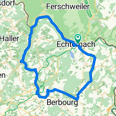
MTB - Echternach - Geyershof - Scheidgen - Melickshof
A cycling route starting in Echternacherbrück, Rhineland-Palatinate, Germany.
Overview
About this route
Eine fast reine Waldroute mit vielen verwirrenden Kreuzungen der Waldwege, die nicht eingezeichnet sind. Fahr bis nach Scheidgen ist auf Asphalt bzw. Schotterweg. Erst dann kommen die richtigen Waldwege und es bereitet auch mehr Spaß.
Auf jeden Fall sollte man die Route gut studieren bevor man losfährt.
Bessere und verständlichere Ansicht in Open Cycle Map.
- -:--
- Duration
- 21.8 km
- Distance
- 367 m
- Ascent
- 366 m
- Descent
- ---
- Avg. speed
- ---
- Max. altitude

Continue with Bikemap
Use, edit, or download this cycling route
You would like to ride MTB - Echternach - Geyershof - Scheidgen - Melickshof or customize it for your own trip? Here is what you can do with this Bikemap route:
Free features
- Save this route as favorite or in collections
- Copy & plan your own version of this route
- Sync your route with Garmin or Wahoo
Premium features
Free trial for 3 days, or one-time payment. More about Bikemap Premium.
- Navigate this route on iOS & Android
- Export a GPX / KML file of this route
- Create your custom printout (try it for free)
- Download this route for offline navigation
Discover more Premium features.
Get Bikemap PremiumFrom our community
Other popular routes starting in Echternacherbrück
 Echternach - Herborn - Consdorf - Müllerthal
- Distance
- 41.9 km
- Ascent
- 623 m
- Descent
- 614 m
- Location
- Echternacherbrück, Rhineland-Palatinate, Germany
 Echternach - Holsthum - Echtershausen - Körperich
- Distance
- 83.9 km
- Ascent
- 1,140 m
- Descent
- 1,113 m
- Location
- Echternacherbrück, Rhineland-Palatinate, Germany
 Echternach-Beaufort-Echternach
- Distance
- 48.5 km
- Ascent
- 493 m
- Descent
- 488 m
- Location
- Echternacherbrück, Rhineland-Palatinate, Germany
 MTB - Echternach - E-See - Berdorf - Hohley
- Distance
- 18.2 km
- Ascent
- 310 m
- Descent
- 309 m
- Location
- Echternacherbrück, Rhineland-Palatinate, Germany
 Echternach - Prümzurlay - Ferschweiler - Weilerbach
- Distance
- 23 km
- Ascent
- 276 m
- Descent
- 276 m
- Location
- Echternacherbrück, Rhineland-Palatinate, Germany
 Die 4 Hügel
- Distance
- 51.6 km
- Ascent
- 831 m
- Descent
- 829 m
- Location
- Echternacherbrück, Rhineland-Palatinate, Germany
 Relaxed route in Echternach
- Distance
- 28.1 km
- Ascent
- 173 m
- Descent
- 230 m
- Location
- Echternacherbrück, Rhineland-Palatinate, Germany
 IV day
- Distance
- 164.1 km
- Ascent
- 1,471 m
- Descent
- 1,382 m
- Location
- Echternacherbrück, Rhineland-Palatinate, Germany
Open it in the app