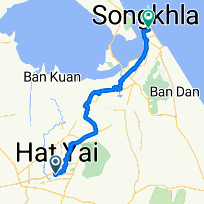
1. Hat Yai to ferry
A cycling route starting in Hat Yai, Songkhla, Thailand.
Overview
About this route
- 10 h 47 min
- Duration
- 173.9 km
- Distance
- 1,117 m
- Ascent
- 1,126 m
- Descent
- 16.1 km/h
- Avg. speed
- 196 m
- Max. altitude
Route quality
Waytypes & surfaces along the route
Waytypes
Quiet road
74.7 km
(43 %)
Road
68.9 km
(40 %)
Surfaces
Paved
40.3 km
(23 %)
Unpaved
3.9 km
(2 %)
Asphalt
39 km
(22 %)
Unpaved (undefined)
3.9 km
(2 %)
Continue with Bikemap
Use, edit, or download this cycling route
You would like to ride 1. Hat Yai to ferry or customize it for your own trip? Here is what you can do with this Bikemap route:
Free features
- Save this route as favorite or in collections
- Copy & plan your own version of this route
- Split it into stages to create a multi-day tour
- Sync your route with Garmin or Wahoo
Premium features
Free trial for 3 days, or one-time payment. More about Bikemap Premium.
- Navigate this route on iOS & Android
- Export a GPX / KML file of this route
- Create your custom printout (try it for free)
- Download this route for offline navigation
Discover more Premium features.
Get Bikemap PremiumFrom our community
Other popular routes starting in Hat Yai
- Route from 66/57 Soi Maneesook, Amphoe Hat Yai
- Distance
- 19.5 km
- Ascent
- 275 m
- Descent
- 145 m
- Location
- Hat Yai, Songkhla, Thailand
- malaisie part 1
- Distance
- 380.3 km
- Ascent
- 393 m
- Descent
- 358 m
- Location
- Hat Yai, Songkhla, Thailand
- āļāļāļ āļĨāļāļāļļāļĢāļĩāļĢāļēāđāļĄāļĻāļ§āļĢāđ 84/59 to āļāļāļ āļāļēāļāļāļāļ§āļāļīāļ 76/7, āļāļģāļāļĨāļāđāļģāļāđāļāļĒ
- Distance
- 12.8 km
- Ascent
- 7 m
- Descent
- 17 m
- Location
- Hat Yai, Songkhla, Thailand
- kickoff
- Distance
- 32.6 km
- Ascent
- 356 m
- Descent
- 349 m
- Location
- Hat Yai, Songkhla, Thailand
- Hat Yai to Songkhla North
- Distance
- 48.1 km
- Ascent
- 380 m
- Descent
- 386 m
- Location
- Hat Yai, Songkhla, Thailand
- Angel ride 2023 final test ride
- Distance
- 78.7 km
- Ascent
- 544 m
- Descent
- 572 m
- Location
- Hat Yai, Songkhla, Thailand
- Ban Thung Pho Alley 49, Tambon Kho Hong to Poonnakan Road 618, Tambon Kho Hong
- Distance
- 69.8 km
- Ascent
- 227 m
- Descent
- 222 m
- Location
- Hat Yai, Songkhla, Thailand
- Quick ride through Amphoe Hat Yai
- Distance
- 7.4 km
- Ascent
- 104 m
- Descent
- 103 m
- Location
- Hat Yai, Songkhla, Thailand
Open it in the app