

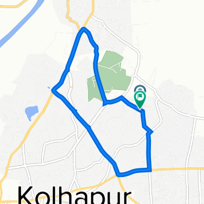
P7X2+33G, Kolhapur to Kasaba Bawada, Kolhapur
A cycling route starting in Kolhāpur, Maharashtra, India.
Overview
About this route
- 26 min
- Duration
- 9.1 km
- Distance
- 69 m
- Ascent
- 59 m
- Descent
- 20.6 km/h
- Avg. speed
- 556 m
- Max. altitude

Route quality
Waytypes & surfaces along the route
Waytypes
Quiet road
0.7 km
(8 %)
Undefined
8.3 km
(92 %)
Continue with Bikemap
Use, edit, or download this cycling route
You would like to ride P7X2+33G, Kolhapur to Kasaba Bawada, Kolhapur or customize it for your own trip? Here is what you can do with this Bikemap route:
Free features
- Save this route as favorite or in collections
- Copy & plan your own version of this route
- Sync your route with Garmin or Wahoo
Premium features
Free trial for 3 days, or one-time payment. More about Bikemap Premium.
- Navigate this route on iOS & Android
- Export a GPX / KML file of this route
- Create your custom printout (try it for free)
- Download this route for offline navigation
Discover more Premium features.
Get Bikemap PremiumFrom our community
Other popular routes starting in Kolhāpur
 Salokhe Nagar Road 37, Kolhapur to Salokhe Nagar Road 37, Kolhapur
- Distance
- 17.6 km
- Ascent
- 16 m
- Descent
- 28 m
- Location
- Kolhāpur, Maharashtra, India
 Slow ride
- Distance
- 12.3 km
- Ascent
- 190 m
- Descent
- 87 m
- Location
- Kolhāpur, Maharashtra, India
 P7X2+33G, Kolhapur to Kasaba Bawada, Kolhapur
- Distance
- 9.1 km
- Ascent
- 69 m
- Descent
- 59 m
- Location
- Kolhāpur, Maharashtra, India
 Kalamba Ring Road, Kolhapur to M686+7G2, Kolhapur
- Distance
- 13.2 km
- Ascent
- 229 m
- Descent
- 152 m
- Location
- Kolhāpur, Maharashtra, India
 morning ride
- Distance
- 7.2 km
- Ascent
- 41 m
- Descent
- 39 m
- Location
- Kolhāpur, Maharashtra, India
 Nerli bridge
- Distance
- 17.3 km
- Ascent
- 253 m
- Descent
- 256 m
- Location
- Kolhāpur, Maharashtra, India
 KOP to Kathmandu
- Distance
- 2,448.1 km
- Ascent
- 2,292 m
- Descent
- 1,574 m
- Location
- Kolhāpur, Maharashtra, India
 Wadanage-Kolhapur Road to Wadanage-Kolhapur Road
- Distance
- 21.8 km
- Ascent
- 386 m
- Descent
- 420 m
- Location
- Kolhāpur, Maharashtra, India
Open it in the app