

France2023 E23
A cycling route starting in Arcachon, Nouvelle-Aquitaine, France.
Overview
About this route
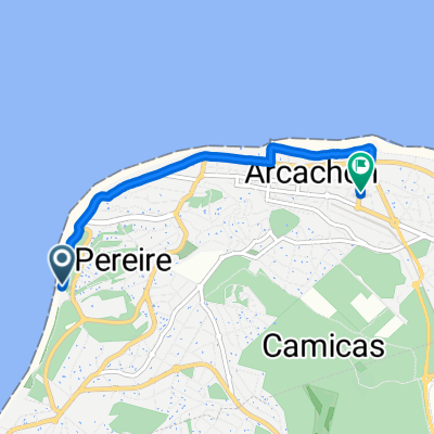
Arcachon - Cap Ferret - Moulis-Listrac Gare
- -:--
- Duration
- 94.3 km
- Distance
- 369 m
- Ascent
- 356 m
- Descent
- ---
- Avg. speed
- 45 m
- Max. altitude

Route quality
Waytypes & surfaces along the route
Waytypes
Cycleway
67 km
(71 %)
Quiet road
15.1 km
(16 %)
Surfaces
Paved
75.5 km
(80 %)
Unpaved
1.9 km
(2 %)
Asphalt
74.5 km
(79 %)
Paved (undefined)
0.9 km
(1 %)
Continue with Bikemap
Use, edit, or download this cycling route
You would like to ride France2023 E23 or customize it for your own trip? Here is what you can do with this Bikemap route:
Free features
- Save this route as favorite or in collections
- Copy & plan your own version of this route
- Split it into stages to create a multi-day tour
- Sync your route with Garmin or Wahoo
Premium features
Free trial for 3 days, or one-time payment. More about Bikemap Premium.
- Navigate this route on iOS & Android
- Export a GPX / KML file of this route
- Create your custom printout (try it for free)
- Download this route for offline navigation
Discover more Premium features.
Get Bikemap PremiumFrom our community
Other popular routes starting in Arcachon
 plage -Hotels.com
- Distance
- 3.7 km
- Ascent
- 12 m
- Descent
- 8 m
- Location
- Arcachon, Nouvelle-Aquitaine, France
 Untitled route
- Distance
- 52 km
- Ascent
- 395 m
- Descent
- 370 m
- Location
- Arcachon, Nouvelle-Aquitaine, France
 De Allée des Sternes 1, Arcachon à Allée des Sternes 1, Arcachon
- Distance
- 21.5 km
- Ascent
- 113 m
- Descent
- 95 m
- Location
- Arcachon, Nouvelle-Aquitaine, France
 Résidence Arcachon Marine, La Teste-de-Buch a Eurovélo 1 - Atlantique Coast Route, La Teste-de-Buch
- Distance
- 25.5 km
- Ascent
- 187 m
- Descent
- 175 m
- Location
- Arcachon, Nouvelle-Aquitaine, France
 De 4 Allée des Souchets, Lège-Cap-Ferret à Allée de la Gélinotte, Lège-Cap-Ferret
- Distance
- 11.3 km
- Ascent
- 3 m
- Descent
- 7 m
- Location
- Arcachon, Nouvelle-Aquitaine, France
 Itinéraire reposant en Arcachon
- Distance
- 16.8 km
- Ascent
- 34 m
- Descent
- 34 m
- Location
- Arcachon, Nouvelle-Aquitaine, France
 Rue du Professeur Jolyet, Arcachon a Lège-Cap-Ferret
- Distance
- 70 km
- Ascent
- 237 m
- Descent
- 239 m
- Location
- Arcachon, Nouvelle-Aquitaine, France
 Cap Ferret - loc
- Distance
- 9.6 km
- Ascent
- 306 m
- Descent
- 311 m
- Location
- Arcachon, Nouvelle-Aquitaine, France
Open it in the app