

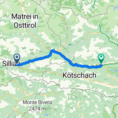
Überschreitung Defreggental ins Winkltal
A cycling route starting in Heinfels, Tyrol, Austria.
Overview
About this route
technically and conditionally very demanding MTB tour, landscape SUPER! Carrying section about 550 m elevation gain, very challenging trail descent about 750 m elevation loss, rest opportunity at Bloshütte (highly recommended)
- -:--
- Duration
- 95.4 km
- Distance
- 2,484 m
- Ascent
- 2,484 m
- Descent
- ---
- Avg. speed
- ---
- Max. altitude

Continue with Bikemap
Use, edit, or download this cycling route
You would like to ride Überschreitung Defreggental ins Winkltal or customize it for your own trip? Here is what you can do with this Bikemap route:
Free features
- Save this route as favorite or in collections
- Copy & plan your own version of this route
- Split it into stages to create a multi-day tour
- Sync your route with Garmin or Wahoo
Premium features
Free trial for 3 days, or one-time payment. More about Bikemap Premium.
- Navigate this route on iOS & Android
- Export a GPX / KML file of this route
- Create your custom printout (try it for free)
- Download this route for offline navigation
Discover more Premium features.
Get Bikemap PremiumFrom our community
Other popular routes starting in Heinfels
 solo_23_2_3_Tassenbach - Brixen
- Distance
- 105.7 km
- Ascent
- 1,184 m
- Descent
- 1,720 m
- Location
- Heinfels, Tyrol, Austria
 Tassenbacher Speicher, Strassen to Arnbacher Loipenweg, Sillian
- Distance
- 5.3 km
- Ascent
- 92 m
- Descent
- 77 m
- Location
- Heinfels, Tyrol, Austria
 From Heinfels to Lienz
- Distance
- 30.9 km
- Ascent
- 370 m
- Descent
- 776 m
- Location
- Heinfels, Tyrol, Austria
 O07LienzerDolomitenGreifenburgBadesee
- Distance
- 69.3 km
- Ascent
- 747 m
- Descent
- 1,231 m
- Location
- Heinfels, Tyrol, Austria
 AT - Day 8 - Weissensee
- Distance
- 74 km
- Ascent
- 445 m
- Descent
- 583 m
- Location
- Heinfels, Tyrol, Austria
 4 etapa tasenbach(AUS)-canizei(ITA)
- Distance
- 109.2 km
- Ascent
- 2,079 m
- Descent
- 1,709 m
- Location
- Heinfels, Tyrol, Austria
 2023_1_lesachtal_
- Distance
- 51.4 km
- Ascent
- 1,357 m
- Descent
- 1,728 m
- Location
- Heinfels, Tyrol, Austria
 Drauraweg
- Distance
- 258.5 km
- Ascent
- 280 m
- Descent
- 981 m
- Location
- Heinfels, Tyrol, Austria
Open it in the app