

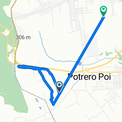
Ruta Pedrozo - Pirayu'i, a -25.349° N -57.229° W
A cycling route starting in Caacupé, Cordillera Department, Paraguay.
Overview
About this route
- 2 h 41 min
- Duration
- 32.4 km
- Distance
- 268 m
- Ascent
- 273 m
- Descent
- 12.1 km/h
- Avg. speed
- 185 m
- Max. altitude
Continue with Bikemap
Use, edit, or download this cycling route
You would like to ride Ruta Pedrozo - Pirayu'i, a -25.349° N -57.229° W or customize it for your own trip? Here is what you can do with this Bikemap route:
Free features
- Save this route as favorite or in collections
- Copy & plan your own version of this route
- Sync your route with Garmin or Wahoo
Premium features
Free trial for 3 days, or one-time payment. More about Bikemap Premium.
- Navigate this route on iOS & Android
- Export a GPX / KML file of this route
- Create your custom printout (try it for free)
- Download this route for offline navigation
Discover more Premium features.
Get Bikemap PremiumFrom our community
Other popular routes starting in Caacupé
 ruta ll
- Distance
- 6.5 km
- Ascent
- 199 m
- Descent
- 249 m
- Location
- Caacupé, Cordillera Department, Paraguay
 Unnamed Road to Avenida Guillerno Naumann, San Bernardino
- Distance
- 12.5 km
- Ascent
- 157 m
- Descent
- 261 m
- Location
- Caacupé, Cordillera Department, Paraguay
 Ruta Pedrozo - Pirayu'i, a -25.349° N -57.229° W
- Distance
- 32.4 km
- Ascent
- 268 m
- Descent
- 273 m
- Location
- Caacupé, Cordillera Department, Paraguay
 Circunvalación Caacupé
- Distance
- 21.7 km
- Ascent
- 473 m
- Descent
- 463 m
- Location
- Caacupé, Cordillera Department, Paraguay
 -25.355° N -57.220° W a -25.349° N -57.229° W
- Distance
- 42.2 km
- Ascent
- 659 m
- Descent
- 671 m
- Location
- Caacupé, Cordillera Department, Paraguay
Open it in the app