

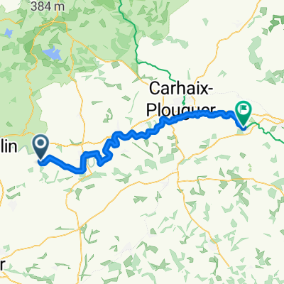
etape 2 pleyben carhaix plouger
A cycling route starting in Gouézec, Brittany Region, France.
Overview
About this route
- -:--
- Duration
- 53.2 km
- Distance
- 472 m
- Ascent
- 419 m
- Descent
- ---
- Avg. speed
- 99 m
- Max. altitude
Route quality
Waytypes & surfaces along the route
Waytypes
Track
40.9 km
(77 %)
Path
6.3 km
(12 %)
Surfaces
Paved
19.3 km
(36 %)
Unpaved
9.6 km
(18 %)
Asphalt
13.7 km
(26 %)
Paved (undefined)
5.6 km
(11 %)
Continue with Bikemap
Use, edit, or download this cycling route
You would like to ride etape 2 pleyben carhaix plouger or customize it for your own trip? Here is what you can do with this Bikemap route:
Free features
- Save this route as favorite or in collections
- Copy & plan your own version of this route
- Sync your route with Garmin or Wahoo
Premium features
Free trial for 3 days, or one-time payment. More about Bikemap Premium.
- Navigate this route on iOS & Android
- Export a GPX / KML file of this route
- Create your custom printout (try it for free)
- Download this route for offline navigation
Discover more Premium features.
Get Bikemap PremiumFrom our community
Other popular routes starting in Gouézec
 DH GOUEZEC
- Distance
- 1.2 km
- Ascent
- 395 m
- Descent
- 395 m
- Location
- Gouézec, Brittany Region, France
 Recovered Route
- Distance
- 21.2 km
- Ascent
- 41 m
- Descent
- 26 m
- Location
- Gouézec, Brittany Region, France
 etape 2 pleyben carhaix plouger
- Distance
- 53.2 km
- Ascent
- 472 m
- Descent
- 419 m
- Location
- Gouézec, Brittany Region, France
 Pont Coblant - Carhaix-Plouguer 70km
- Distance
- 70.3 km
- Ascent
- 329 m
- Descent
- 261 m
- Location
- Gouézec, Brittany Region, France
 De Rue des Ardoisiers 23, Pleyben à Le Nivernic, Carhaix-Plouguer
- Distance
- 58.2 km
- Ascent
- 517 m
- Descent
- 439 m
- Location
- Gouézec, Brittany Region, France
 pleyben - crozon
- Distance
- 64 km
- Ascent
- 656 m
- Descent
- 672 m
- Location
- Gouézec, Brittany Region, France
 Gouézec - Glomel
- Distance
- 60.4 km
- Ascent
- 767 m
- Descent
- 625 m
- Location
- Gouézec, Brittany Region, France
 Descente Gouézec TOP
- Distance
- 1.7 km
- Ascent
- 0 m
- Descent
- 155 m
- Location
- Gouézec, Brittany Region, France
Open it in the app