

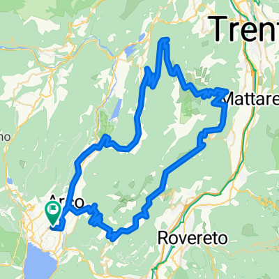
Arco über St. Giovanni zum Tennosee nach Arco
A cycling route starting in Arco, Trentino-Alto Adige, Italy.
Overview
About this route
Through side paths to the asphalt climb to St. Giovanni. Beautiful ascent. Then over gravel, concrete paths, and forest trails to Ville dei Monte. Towards Lake Tenno along the beautiful shore. Stairs up and the beautiful descent back to Arco.
- -:--
- Duration
- 40.7 km
- Distance
- 1,304 m
- Ascent
- 1,304 m
- Descent
- ---
- Avg. speed
- ---
- Max. altitude

Continue with Bikemap
Use, edit, or download this cycling route
You would like to ride Arco über St. Giovanni zum Tennosee nach Arco or customize it for your own trip? Here is what you can do with this Bikemap route:
Free features
- Save this route as favorite or in collections
- Copy & plan your own version of this route
- Sync your route with Garmin or Wahoo
Premium features
Free trial for 3 days, or one-time payment. More about Bikemap Premium.
- Navigate this route on iOS & Android
- Export a GPX / KML file of this route
- Create your custom printout (try it for free)
- Download this route for offline navigation
Discover more Premium features.
Get Bikemap PremiumFrom our community
Other popular routes starting in Arco
 Via Paolina Caproni Maini 14, Arco nach Via Bettega 3, Molveno
- Distance
- 43.9 km
- Ascent
- 1,028 m
- Descent
- 265 m
- Location
- Arco, Trentino-Alto Adige, Italy
 Arco, Race, 101 km, 3000 Hm, Monte Velo - Umrundung Monte Bordone, Var 2
- Distance
- 98.4 km
- Ascent
- 3,267 m
- Descent
- 3,266 m
- Location
- Arco, Trentino-Alto Adige, Italy
 Arco - Santa Barbara
- Distance
- 39 km
- Ascent
- 1,135 m
- Descent
- 1,132 m
- Location
- Arco, Trentino-Alto Adige, Italy
 arco
arco- Distance
- 14.3 km
- Ascent
- 620 m
- Descent
- 620 m
- Location
- Arco, Trentino-Alto Adige, Italy
 Arco - Passo S.Giovanni - Arco
- Distance
- 33.2 km
- Ascent
- 1,163 m
- Descent
- 1,165 m
- Location
- Arco, Trentino-Alto Adige, Italy
 Monte Velo
- Distance
- 32.8 km
- Ascent
- 1,266 m
- Descent
- 1,266 m
- Location
- Arco, Trentino-Alto Adige, Italy
 Garda_Tour 1
- Distance
- 143.7 km
- Ascent
- 2,886 m
- Descent
- 2,883 m
- Location
- Arco, Trentino-Alto Adige, Italy
 I_Trentino_Arco-Ceniga-Gaggiolo-Isoletta-Pietramurata_rechteSeitezurück-RR-29km-320hm_(Gardatrenino.it-750.Marocche)
- Distance
- 28.9 km
- Ascent
- 397 m
- Descent
- 394 m
- Location
- Arco, Trentino-Alto Adige, Italy
Open it in the app