

sarcelles coye 52 AR
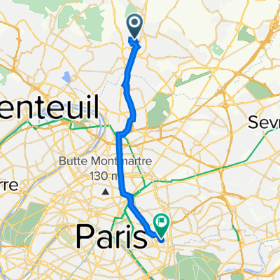
A cycling route starting in Sarcelles, Île-de-France Region, France.
Overview
About this route
Metadata: Name: exp_sarcelles coye 52 AR.gpx Author: Mobile User Description: (null) {DC1}End time: Total duration: 0h00:00 Overall average: - Average slope: 0.00 % Included area: 1322.9658 ha Boundary points: 49.1564 2.3642 ; 48.9972 2.4933 Segment details distance | duration | avg. speed | max speed | elevation gain | elevation loss km | hh:mm:ss | km/h | km/h | m | m 26.60 | 00:00:00 | 0.0 | 0.0 | 0 | 0{DC2} Original group: [new]
- 3 h 25 min
- Duration
- 26.6 km
- Distance
- 0 m
- Ascent
- 0 m
- Descent
- 7.8 km/h
- Avg. speed
- 0 m
- Max. altitude

Route quality
Waytypes & surfaces along the route
Waytypes
Track
15.4 km
(58 %)
Quiet road
5.1 km
(19 %)
Surfaces
Paved
5.3 km
(20 %)
Unpaved
11.7 km
(44 %)
Gravel
6.4 km
(24 %)
Asphalt
3.2 km
(12 %)
Continue with Bikemap
Use, edit, or download this cycling route
You would like to ride sarcelles coye 52 AR or customize it for your own trip? Here is what you can do with this Bikemap route:
Free features
- Save this route as favorite or in collections
- Copy & plan your own version of this route
- Sync your route with Garmin or Wahoo
Premium features
Free trial for 3 days, or one-time payment. More about Bikemap Premium.
- Navigate this route on iOS & Android
- Export a GPX / KML file of this route
- Create your custom printout (try it for free)
- Download this route for offline navigation
Discover more Premium features.
Get Bikemap PremiumFrom our community
Other popular routes starting in Sarcelles
 sarcelles coye 52 AR
- Distance
- 26.6 km
- Ascent
- 0 m
- Descent
- 0 m
- Location
- Sarcelles, Île-de-France Region, France
 Sarcelles-Chemin de la fontaine
- Distance
- 31.2 km
- Ascent
- 358 m
- Descent
- 358 m
- Location
- Sarcelles, Île-de-France Region, France
 2–4 Rue de Giraudon, Sarcelles à 12 Rue de la Réunion, Paris
- Distance
- 20.2 km
- Ascent
- 116 m
- Descent
- 117 m
- Location
- Sarcelles, Île-de-France Region, France
 sarcelles au 140
- Distance
- 16.8 km
- Ascent
- 109 m
- Descent
- 77 m
- Location
- Sarcelles, Île-de-France Region, France
 De Rue des Noyers 15, Sarcelles à Rue du Maréchal Leclerc 54, Écouen
- Distance
- 4.1 km
- Ascent
- 81 m
- Descent
- 25 m
- Location
- Sarcelles, Île-de-France Region, France
 De 35 Rue Beauséjour, Sarcelles à 35 Rue Beauséjour, Sarcelles
- Distance
- 19.6 km
- Ascent
- 162 m
- Descent
- 163 m
- Location
- Sarcelles, Île-de-France Region, France
 De 35 Rue Beauséjour, Sarcelles à 35 Rue Beauséjour, Sarcelles
- Distance
- 25.9 km
- Ascent
- 208 m
- Descent
- 208 m
- Location
- Sarcelles, Île-de-France Region, France
 Itinéraire vers 18bis Rue des Alouettes, Montmorency
- Distance
- 7.4 km
- Ascent
- 25 m
- Descent
- 43 m
- Location
- Sarcelles, Île-de-France Region, France
Open it in the app