

Lago di Garda e Dolomiti
G7 - Malcesine - Bardolino
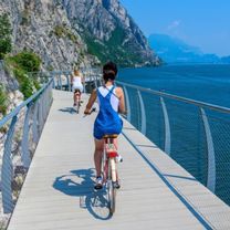
A cycling route starting in Malcesine, Veneto, Italy.
Overview
About this route
8
Saída de Hotel Malcesine, passando por Garda, rumo ao Hotel Benacus, no centro de Bardolino
- -:--
- Duration
- 32.1 km
- Distance
- 206 m
- Ascent
- 205 m
- Descent
- ---
- Avg. speed
- 98 m
- Max. altitude
Mario Fittipaldi
created this 3 years ago
Part of
Lago di Garda e Dolomiti
9 stages
Route quality
Waytypes & surfaces along the route
Waytypes
Cycleway
3.5 km
11 %
Quiet road
1.9 km
6 %
Surfaces
Paved
28.9 km
(90 %)
Asphalt
25.3 km
79 %
Concrete
3.5 km
11 %
Undefined
3.2 km
10 %
Route highlights
Points of interest along the route

Point of interest after 20.9 km
Castelo Scaligero di Malcesine
Continue with Bikemap
Use, edit, or download this cycling route
You would like to ride G7 - Malcesine - Bardolino or customize it for your own trip? Here is what you can do with this Bikemap route:
Free features
- Save this route as favorite or in collections
- Copy & plan your own version of this route
- Sync your route with Garmin or Wahoo
Premium features
Free trial for 3 days, or one-time payment. More about Bikemap Premium.
- Navigate this route on iOS & Android
- Export a GPX / KML file of this route
- Create your custom printout (try it for free)
- Download this route for offline navigation
Discover more Premium features.
Get Bikemap PremiumFrom our community
Other popular routes starting in Malcesine
- Via Castello, Malcesine a Via IV Novembre, Limone sul Garda0
- 33.8 km
- 615 m
- 619 m
- Malcesine, Veneto, Italy


Open it in the app