

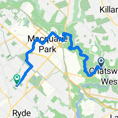
13 Plassey Rd, Macquarie Park to 1003 Upper Fort St, Millers Point
A cycling route starting in Chatswood West, New South Wales, Australia.
Overview
About this route
- 1 h 49 min
- Duration
- 16.2 km
- Distance
- 304 m
- Ascent
- 323 m
- Descent
- 8.9 km/h
- Avg. speed
- 117 m
- Max. altitude

Route quality
Waytypes & surfaces along the route
Waytypes
Cycleway
9.7 km
(60 %)
Pedestrian area
2.6 km
(16 %)
Surfaces
Paved
8.3 km
(51 %)
Asphalt
4.1 km
(25 %)
Concrete
3.9 km
(24 %)
Continue with Bikemap
Use, edit, or download this cycling route
You would like to ride 13 Plassey Rd, Macquarie Park to 1003 Upper Fort St, Millers Point or customize it for your own trip? Here is what you can do with this Bikemap route:
Free features
- Save this route as favorite or in collections
- Copy & plan your own version of this route
- Sync your route with Garmin or Wahoo
Premium features
Free trial for 3 days, or one-time payment. More about Bikemap Premium.
- Navigate this route on iOS & Android
- Export a GPX / KML file of this route
- Create your custom printout (try it for free)
- Download this route for offline navigation
Discover more Premium features.
Get Bikemap PremiumFrom our community
Other popular routes starting in Chatswood West
 Restful route in Lindfield
- Distance
- 12 km
- Ascent
- 128 m
- Descent
- 139 m
- Location
- Chatswood West, New South Wales, Australia
 River Ave, North Ryde to Quarry Rd, Ryde
- Distance
- 10.1 km
- Ascent
- 176 m
- Descent
- 108 m
- Location
- Chatswood West, New South Wales, Australia
 Lindfield to Quarry Rd, Ryde
- Distance
- 10.3 km
- Ascent
- 204 m
- Descent
- 138 m
- Location
- Chatswood West, New South Wales, Australia
 13 Plassey Rd, Macquarie Park to 1003 Upper Fort St, Millers Point
- Distance
- 16.2 km
- Ascent
- 304 m
- Descent
- 323 m
- Location
- Chatswood West, New South Wales, Australia
 Max Allen Road 2, Lindfield to Wongala Crescent 1A, Beecroft
- Distance
- 17 km
- Ascent
- 332 m
- Descent
- 214 m
- Location
- Chatswood West, New South Wales, Australia
 Max Allen Road 2, Lindfield to Malton Road 10A, Beecroft
- Distance
- 19.4 km
- Ascent
- 413 m
- Descent
- 300 m
- Location
- Chatswood West, New South Wales, Australia
 13 Plassey Rd, Macquarie Park to 2A Bradleys Head Rd, Mosman
- Distance
- 16.6 km
- Ascent
- 260 m
- Descent
- 257 m
- Location
- Chatswood West, New South Wales, Australia
 Riverside Drive, Macquarie Park to 646V+J5R, Macquarie Park
- Distance
- 91.6 km
- Ascent
- 481 m
- Descent
- 454 m
- Location
- Chatswood West, New South Wales, Australia
Open it in the app