Rifugio Città di Fiume - Forcella Ambrizzola -Croda del Lago
A cycling route starting in Selva di Cadore, Veneto, Italy.
Overview
About this route
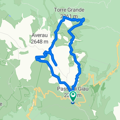
1h Rif. Città di Fiume
2h Malga Prendera
3h 15min Forcella Ambrizzola
- -:--
- Duration
- 9.1 km
- Distance
- 697 m
- Ascent
- 320 m
- Descent
- ---
- Avg. speed
- 2,311 m
- Avg. speed
Route highlights
Points of interest along the route
Point of interest after 6.5 km
Cima Col Duro. Molto panoramica, dalla forcella si sale prima ripido poi meno (non distante)
Point of interest after 7.2 km
FORCELLA AMBRIZZOLA (vista su Croda del Lago e Cortina)
Continue with Bikemap
Use, edit, or download this cycling route
You would like to ride Rifugio Città di Fiume - Forcella Ambrizzola -Croda del Lago or customize it for your own trip? Here is what you can do with this Bikemap route:
Free features
- Save this route as favorite or in collections
- Copy & plan your own version of this route
- Sync your route with Garmin or Wahoo
Premium features
Free trial for 3 days, or one-time payment. More about Bikemap Premium.
- Navigate this route on iOS & Android
- Export a GPX / KML file of this route
- Create your custom printout (try it for free)
- Download this route for offline navigation
Discover more Premium features.
Get Bikemap PremiumFrom our community
Other popular routes starting in Selva di Cadore
- Q 9/16 Selva di Cadore to Palmanova
- Distance
- 171 km
- Ascent
- 787 m
- Descent
- 2,191 m
- Location
- Selva di Cadore, Veneto, Italy
- Rifugio Città di Fiume - Forcella Ambrizzola -Croda del Lago
- Distance
- 9.1 km
- Ascent
- 697 m
- Descent
- 320 m
- Location
- Selva di Cadore, Veneto, Italy
- Dolomiten Trail Cross: Etappe 4: Rif. Averau - St. Martino de Castrozza
- Distance
- 63 km
- Ascent
- 1,727 m
- Descent
- 2,641 m
- Location
- Selva di Cadore, Veneto, Italy
- MARMOLADA Y SAN PELEGRINO
- Distance
- 96.3 km
- Ascent
- 2,329 m
- Descent
- 2,311 m
- Location
- Selva di Cadore, Veneto, Italy
- Rifugio Città di Fiume - Malga Prendera - Forcella Ambrizzola - Mondeval
- Distance
- 16.7 km
- Ascent
- 874 m
- Descent
- 866 m
- Location
- Selva di Cadore, Veneto, Italy
- Anello Passo Giau - 5 Torri
- Distance
- 10.9 km
- Ascent
- 571 m
- Descent
- 571 m
- Location
- Selva di Cadore, Veneto, Italy
- Pocol-Cortina-PassoGiau-Rif.Fedare-CinqueTorri-SR48-Pocol
- Distance
- 26.2 km
- Ascent
- 1,140 m
- Descent
- 1,135 m
- Location
- Selva di Cadore, Veneto, Italy
- Sellaronda con partenza da Santa Fosca
- Distance
- 103.8 km
- Ascent
- 2,293 m
- Descent
- 2,293 m
- Location
- Selva di Cadore, Veneto, Italy
Open it in the app