
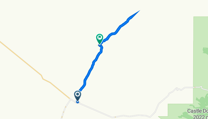
S Helvetia Rd, Sonoita to Road 411, Sahuarita
A cycling route starting in Green Valley, Arizona, United States of America.
Overview
About this route
- 57 min
- Duration
- 9.9 km
- Distance
- 142 m
- Ascent
- 144 m
- Descent
- 10.5 km/h
- Avg. speed
- 1,163 m
- Avg. speed

Continue with Bikemap
Use, edit, or download this cycling route
You would like to ride S Helvetia Rd, Sonoita to Road 411, Sahuarita or customize it for your own trip? Here is what you can do with this Bikemap route:
Free features
- Save this route as favorite or in collections
- Copy & plan your own version of this route
- Sync your route with Garmin or Wahoo
Premium features
Free trial for 3 days, or one-time payment. More about Bikemap Premium.
- Navigate this route on iOS & Android
- Export a GPX / KML file of this route
- Create your custom printout (try it for free)
- Download this route for offline navigation
Discover more Premium features.
Get Bikemap PremiumFrom our community
Other popular routes starting in Green Valley
 S Helvetia Rd, Sonoita to Road 411, Sahuarita
- Distance
- 9.9 km
- Ascent
- 142 m
- Descent
- 144 m
- Location
- Green Valley, Arizona, United States of America
 Home to Mission
- Distance
- 44 km
- Ascent
- 274 m
- Descent
- 273 m
- Location
- Green Valley, Arizona, United States of America
 749 N Rugged Canyon Dr, Green Valley to 121 W Calle Nogal, Green Valley
- Distance
- 4.7 km
- Ascent
- 17 m
- Descent
- 68 m
- Location
- Green Valley, Arizona, United States of America
 NE-130316 - Tucson Bicycle Classic - Stage 01
- Distance
- 33.2 km
- Ascent
- 236 m
- Descent
- 236 m
- Location
- Green Valley, Arizona, United States of America
 720 N Observation Trail, Green Valley to E Sam Lena Dr, Tucson
- Distance
- 70.3 km
- Ascent
- 227 m
- Descent
- 367 m
- Location
- Green Valley, Arizona, United States of America
 Madera Highlands to South Tucson loop via Wilmont
- Distance
- 76.9 km
- Ascent
- 133 m
- Descent
- 135 m
- Location
- Green Valley, Arizona, United States of America
 S Helvetia Rd, Sonoita to S Helvetia Rd, Green Valley
- Distance
- 13.5 km
- Ascent
- 174 m
- Descent
- 183 m
- Location
- Green Valley, Arizona, United States of America
 Continental/Mission to Helmet Peak
- Distance
- 38.9 km
- Ascent
- 235 m
- Descent
- 238 m
- Location
- Green Valley, Arizona, United States of America
Open it in the app