

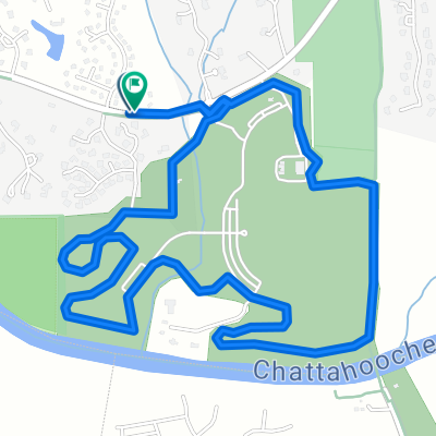
3395 Peachtree Industrial Blvd, Duluth to Silver Comet Trail, Powder Springs
A cycling route starting in Duluth, Georgia, United States.
Overview
About this route
- 4 h 12 min
- Duration
- 63.5 km
- Distance
- 691 m
- Ascent
- 697 m
- Descent
- 15.1 km/h
- Avg. speed
- 361 m
- Max. altitude

Route quality
Waytypes & surfaces along the route
Waytypes
Cycleway
28.6 km
(45 %)
Road
17.8 km
(28 %)
Surfaces
Paved
43.8 km
(69 %)
Asphalt
19.7 km
(31 %)
Paved (undefined)
12.7 km
(20 %)
Continue with Bikemap
Use, edit, or download this cycling route
You would like to ride 3395 Peachtree Industrial Blvd, Duluth to Silver Comet Trail, Powder Springs or customize it for your own trip? Here is what you can do with this Bikemap route:
Free features
- Save this route as favorite or in collections
- Copy & plan your own version of this route
- Sync your route with Garmin or Wahoo
Premium features
Free trial for 3 days, or one-time payment. More about Bikemap Premium.
- Navigate this route on iOS & Android
- Export a GPX / KML file of this route
- Create your custom printout (try it for free)
- Download this route for offline navigation
Discover more Premium features.
Get Bikemap PremiumFrom our community
Other popular routes starting in Duluth
 3395 Peachtree Industrial Blvd, Duluth to Silver Comet Trail, Powder Springs
- Distance
- 63.5 km
- Ascent
- 691 m
- Descent
- 697 m
- Location
- Duluth, Georgia, United States
 Short ride from Lawrenceville to Duluth
- Distance
- 5.3 km
- Ascent
- 70 m
- Descent
- 29 m
- Location
- Duluth, Georgia, United States
 Parkside Club Ct, Johns Creek to Parkside Club Ct, Johns Creek
- Distance
- 6.2 km
- Ascent
- 26 m
- Descent
- 27 m
- Location
- Duluth, Georgia, United States
 3631 E Bay St, Duluth to 3543 Peachtree Industrial Blvd, Duluth
- Distance
- 1.8 km
- Ascent
- 13 m
- Descent
- 26 m
- Location
- Duluth, Georgia, United States
 3079 Premiere Pkwy, Duluth to 2222 Duluth Hwy, Duluth
- Distance
- 13.8 km
- Ascent
- 66 m
- Descent
- 98 m
- Location
- Duluth, Georgia, United States
 Abbotts Bridge Rd, Duluth to 312 Oakland Hills Way, Lawrenceville
- Distance
- 17.6 km
- Ascent
- 366 m
- Descent
- 365 m
- Location
- Duluth, Georgia, United States
 Primerica Pkwy, Duluth to 11765 Jones Bridge Rd, Johns Creek
- Distance
- 23.2 km
- Ascent
- 312 m
- Descent
- 257 m
- Location
- Duluth, Georgia, United States
 Bell Rd, Johns Creek to Parkside Club Ct, Johns Creek
- Distance
- 5.6 km
- Ascent
- 13 m
- Descent
- 3 m
- Location
- Duluth, Georgia, United States
Open it in the app