
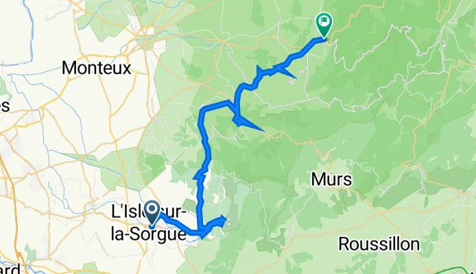
L'Isle-sur-la-Sorgue - Villes-sur-Auzon
A cycling route starting in L’Isle-sur-la-Sorgue, Provence-Alpes-Côte d'Azur Region, France.
Overview
About this route
- -:--
- Duration
- 43.2 km
- Distance
- 857 m
- Ascent
- 623 m
- Descent
- ---
- Avg. speed
- 389 m
- Avg. speed

Route quality
Waytypes & surfaces along the route
Waytypes
Road
29.7 km
(69 %)
Quiet road
6.6 km
(15 %)
Surfaces
Paved
34.3 km
(79 %)
Asphalt
32.1 km
(74 %)
Concrete
2.3 km
(5 %)
Undefined
8.9 km
(21 %)
Continue with Bikemap
Use, edit, or download this cycling route
You would like to ride L'Isle-sur-la-Sorgue - Villes-sur-Auzon or customize it for your own trip? Here is what you can do with this Bikemap route:
Free features
- Save this route as favorite or in collections
- Copy & plan your own version of this route
- Sync your route with Garmin or Wahoo
Premium features
Free trial for 3 days, or one-time payment. More about Bikemap Premium.
- Navigate this route on iOS & Android
- Export a GPX / KML file of this route
- Create your custom printout (try it for free)
- Download this route for offline navigation
Discover more Premium features.
Get Bikemap PremiumFrom our community
Other popular routes starting in L’Isle-sur-la-Sorgue
 Dia 1 - Sorgue a Bonnieux
- Distance
- 40.7 km
- Ascent
- 725 m
- Descent
- 405 m
- Location
- L’Isle-sur-la-Sorgue, Provence-Alpes-Côte d'Azur Region, France
 quäldich - Provence, E1 In den Schluchten der Vaucluse plus
- Distance
- 117 km
- Ascent
- 1,395 m
- Descent
- 1,394 m
- Location
- L’Isle-sur-la-Sorgue, Provence-Alpes-Côte d'Azur Region, France
 Provence from Mont Ventoux to L'Isle-Sur-La-Sorgue
- Distance
- 21.4 km
- Ascent
- 19 m
- Descent
- 17 m
- Location
- L’Isle-sur-la-Sorgue, Provence-Alpes-Côte d'Azur Region, France
 Provence Stroll on the banks of the Sorgue
- Distance
- 25.3 km
- Ascent
- 12 m
- Descent
- 14 m
- Location
- L’Isle-sur-la-Sorgue, Provence-Alpes-Côte d'Azur Region, France
 Provence_2020_3: Col de Murs - Gordes
- Distance
- 72.1 km
- Ascent
- 895 m
- Descent
- 895 m
- Location
- L’Isle-sur-la-Sorgue, Provence-Alpes-Côte d'Azur Region, France
 L'Isle sur la Sorgue to Malaucène
- Distance
- 38.3 km
- Ascent
- 517 m
- Descent
- 237 m
- Location
- L’Isle-sur-la-Sorgue, Provence-Alpes-Côte d'Azur Region, France
 L'Isle - Arles und zurück
- Distance
- 133.8 km
- Ascent
- 307 m
- Descent
- 306 m
- Location
- L’Isle-sur-la-Sorgue, Provence-Alpes-Côte d'Azur Region, France
 L'Isle-sur-la-Sorgue bis Fontaine
- Distance
- 17.9 km
- Ascent
- 174 m
- Descent
- 176 m
- Location
- L’Isle-sur-la-Sorgue, Provence-Alpes-Côte d'Azur Region, France
Open it in the app