
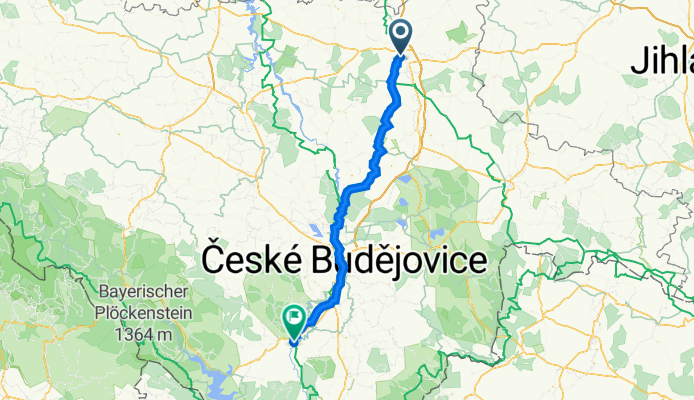
Draft - Greg Tabor to Cesky Krumlov
A cycling route starting in Tábor, Jihočeský kraj, Czechia.
Overview
About this route
Draft
- -:--
- Duration
- 90.3 km
- Distance
- 1,126 m
- Ascent
- 1,094 m
- Descent
- ---
- Avg. speed
- 580 m
- Max. altitude
Route quality
Waytypes & surfaces along the route
Waytypes
Road
50.3 km
(56 %)
Quiet road
16.2 km
(18 %)
Surfaces
Paved
58 km
(64 %)
Unpaved
4.5 km
(5 %)
Asphalt
55.3 km
(61 %)
Gravel
2.3 km
(3 %)
Continue with Bikemap
Use, edit, or download this cycling route
You would like to ride Draft - Greg Tabor to Cesky Krumlov or customize it for your own trip? Here is what you can do with this Bikemap route:
Free features
- Save this route as favorite or in collections
- Copy & plan your own version of this route
- Split it into stages to create a multi-day tour
- Sync your route with Garmin or Wahoo
Premium features
Free trial for 3 days, or one-time payment. More about Bikemap Premium.
- Navigate this route on iOS & Android
- Export a GPX / KML file of this route
- Create your custom printout (try it for free)
- Download this route for offline navigation
Discover more Premium features.
Get Bikemap PremiumFrom our community
Other popular routes starting in Tábor
 100508_Tábor
- Distance
- 28.8 km
- Ascent
- 255 m
- Descent
- 255 m
- Location
- Tábor, Jihočeský kraj, Czechia
 Berlin - Prag Etappe 22 Tabor - Tynec nad Sazavou
- Distance
- 73.9 km
- Ascent
- 826 m
- Descent
- 1,019 m
- Location
- Tábor, Jihočeský kraj, Czechia
 Prag - Wien Etappe 3 - Von Tábor bis Nová Bystřice
- Distance
- 84.1 km
- Ascent
- 1,180 m
- Descent
- 980 m
- Location
- Tábor, Jihočeský kraj, Czechia
 Tabor to Ceske Budejovice
- Distance
- 64.7 km
- Ascent
- 471 m
- Descent
- 418 m
- Location
- Tábor, Jihočeský kraj, Czechia
 MLADOVOŽICKO Z TÁBORA
- Distance
- 52.4 km
- Ascent
- 545 m
- Descent
- 533 m
- Location
- Tábor, Jihočeský kraj, Czechia
 3 - 7
3 - 7- Distance
- 2.4 km
- Ascent
- 53 m
- Descent
- 82 m
- Location
- Tábor, Jihočeský kraj, Czechia
 Trénink od Agipu
- Distance
- 62.4 km
- Ascent
- 276 m
- Descent
- 276 m
- Location
- Tábor, Jihočeský kraj, Czechia
 Rakusko-komplet z Tabora
- Distance
- 300.7 km
- Ascent
- 1,127 m
- Descent
- 1,058 m
- Location
- Tábor, Jihočeský kraj, Czechia
Open it in the app