

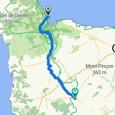
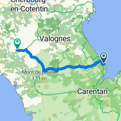
England France Wednesday 19 July
A cycling route starting in Sainte-Mère-Église, Normandy, France.
Overview
About this route
- -:--
- Duration
- 62.6 km
- Distance
- 422 m
- Ascent
- 422 m
- Descent
- ---
- Avg. speed
- 136 m
- Max. altitude

Route quality
Waytypes & surfaces along the route
Waytypes
Road
29.8 km
(48 %)
Quiet road
18.1 km
(29 %)
Surfaces
Paved
41.8 km
(67 %)
Unpaved
0.9 km
(1 %)
Asphalt
41.7 km
(67 %)
Gravel
0.9 km
(1 %)
Continue with Bikemap
Use, edit, or download this cycling route
You would like to ride England France Wednesday 19 July or customize it for your own trip? Here is what you can do with this Bikemap route:
Free features
- Save this route as favorite or in collections
- Copy & plan your own version of this route
- Sync your route with Garmin or Wahoo
Premium features
Free trial for 3 days, or one-time payment. More about Bikemap Premium.
- Navigate this route on iOS & Android
- Export a GPX / KML file of this route
- Create your custom printout (try it for free)
- Download this route for offline navigation
Discover more Premium features.
Get Bikemap PremiumFrom our community
Other popular routes starting in Sainte-Mère-Église
 Utah beach - St Vast
- Distance
- 28 km
- Ascent
- 57 m
- Descent
- 55 m
- Location
- Sainte-Mère-Église, Normandy, France
 Utah Beach to Vire, following the Guidon of the 24th Cavalry Recon Sqdn, Battle of Normandie, 1944
- Distance
- 93.1 km
- Ascent
- 532 m
- Descent
- 355 m
- Location
- Sainte-Mère-Église, Normandy, France
 Normandy 2013
- Distance
- 37.4 km
- Ascent
- 126 m
- Descent
- 122 m
- Location
- Sainte-Mère-Église, Normandy, France
 Tour de Manchette Part II - Jour 4 - 1/2
- Distance
- 35.3 km
- Ascent
- 43 m
- Descent
- 56 m
- Location
- Sainte-Mère-Église, Normandy, France
 England France Wednesday 19 July
- Distance
- 62.6 km
- Ascent
- 422 m
- Descent
- 422 m
- Location
- Sainte-Mère-Église, Normandy, France
 14 Rue Eisenhower, Sainte-Mère-Eglise nach Normandy, Ravenoville
- Distance
- 11.3 km
- Ascent
- 22 m
- Descent
- 47 m
- Location
- Sainte-Mère-Église, Normandy, France
 Utah Beach to Vire, following the Guidon of the 24th Cavalry Recon Sqdn, Battle of Normandie, 1944
- Distance
- 93.1 km
- Ascent
- 530 m
- Descent
- 356 m
- Location
- Sainte-Mère-Église, Normandy, France
 02TDF2016
- Distance
- 49.2 km
- Ascent
- 290 m
- Descent
- 228 m
- Location
- Sainte-Mère-Église, Normandy, France
Open it in the app