
Ohler- Galgen
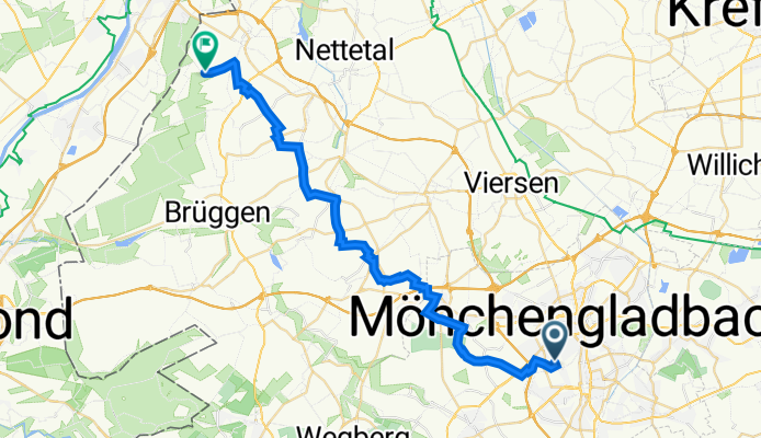
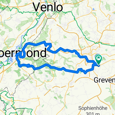
A cycling route starting in Mönchengladbach, North Rhine-Westphalia, Germany.
Overview
About this route
- -:--
- Duration
- 31.9 km
- Distance
- 55 m
- Ascent
- 71 m
- Descent
- ---
- Avg. speed
- 85 m
- Avg. speed
Route quality
Waytypes & surfaces along the route
Waytypes
Quiet road
17.6 km
(55 %)
Track
9.1 km
(29 %)
Surfaces
Paved
13 km
(41 %)
Unpaved
2.1 km
(6 %)
Asphalt
8 km
(25 %)
Paved (undefined)
4.4 km
(14 %)
Continue with Bikemap
Use, edit, or download this cycling route
You would like to ride Ohler- Galgen or customize it for your own trip? Here is what you can do with this Bikemap route:
Free features
- Save this route as favorite or in collections
- Copy & plan your own version of this route
- Sync your route with Garmin or Wahoo
Premium features
Free trial for 3 days, or one-time payment. More about Bikemap Premium.
- Navigate this route on iOS & Android
- Export a GPX / KML file of this route
- Create your custom printout (try it for free)
- Download this route for offline navigation
Discover more Premium features.
Get Bikemap PremiumFrom our community
Other popular routes starting in Mönchengladbach
 Ruckes40
- Distance
- 41.3 km
- Ascent
- 37 m
- Descent
- 43 m
- Location
- Mönchengladbach, North Rhine-Westphalia, Germany
 Von Rheydt zum Adolfosee bei Hückelhoven an der Rur
- Distance
- 58.6 km
- Ascent
- 118 m
- Descent
- 118 m
- Location
- Mönchengladbach, North Rhine-Westphalia, Germany
 Mönchengladbach
- Distance
- 39.3 km
- Ascent
- 113 m
- Descent
- 113 m
- Location
- Mönchengladbach, North Rhine-Westphalia, Germany
 Venn-Holtmühle-Tüschenbroich-Venn
- Distance
- 41.5 km
- Ascent
- 85 m
- Descent
- 83 m
- Location
- Mönchengladbach, North Rhine-Westphalia, Germany
 Zigarren holen in Holland
- Distance
- 106.1 km
- Ascent
- 204 m
- Descent
- 186 m
- Location
- Mönchengladbach, North Rhine-Westphalia, Germany
 Liedberg, korschenbroich
- Distance
- 22.9 km
- Ascent
- 142 m
- Descent
- 140 m
- Location
- Mönchengladbach, North Rhine-Westphalia, Germany
 Radeln für die Seele. Seen am Niederrhein
- Distance
- 60.7 km
- Ascent
- 179 m
- Descent
- 179 m
- Location
- Mönchengladbach, North Rhine-Westphalia, Germany
 Haus Horst - Trietenbroich - Volksgarten
- Distance
- 32 km
- Ascent
- 93 m
- Descent
- 88 m
- Location
- Mönchengladbach, North Rhine-Westphalia, Germany
Open it in the app