

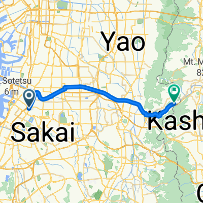
渡船場―夢洲ルート
A cycling route starting in Sakai, Osaka, Japan.
Overview
About this route
- -:--
- Duration
- 41.1 km
- Distance
- 143 m
- Ascent
- 148 m
- Descent
- ---
- Avg. speed
- 24 m
- Max. altitude

Continue with Bikemap
Use, edit, or download this cycling route
You would like to ride 渡船場―夢洲ルート or customize it for your own trip? Here is what you can do with this Bikemap route:
Free features
- Save this route as favorite or in collections
- Copy & plan your own version of this route
- Sync your route with Garmin or Wahoo
Premium features
Free trial for 3 days, or one-time payment. More about Bikemap Premium.
- Navigate this route on iOS & Android
- Export a GPX / KML file of this route
- Create your custom printout (try it for free)
- Download this route for offline navigation
Discover more Premium features.
Get Bikemap PremiumFrom our community
Other popular routes starting in Sakai
 7-15, Tezukayamahigashi 4-Chōme, Sumiyoshi, Osaka to 1-35, Kitahorie 1-Chōme, Nishi, Osaka
- Distance
- 7.7 km
- Ascent
- 31 m
- Descent
- 33 m
- Location
- Sakai, Osaka, Japan
 渡船場―夢洲ルート
- Distance
- 41.1 km
- Ascent
- 143 m
- Descent
- 148 m
- Location
- Sakai, Osaka, Japan
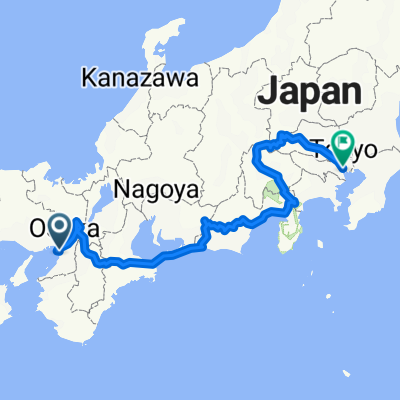 japan
japan- Distance
- 975 km
- Ascent
- 5,309 m
- Descent
- 5,294 m
- Location
- Sakai, Osaka, Japan
 浅香ツツジ→堺駅
- Distance
- 5.6 km
- Ascent
- 10 m
- Descent
- 12 m
- Location
- Sakai, Osaka, Japan
 From Osaka to Tokyo
- Distance
- 886.2 km
- Ascent
- 10,508 m
- Descent
- 10,502 m
- Location
- Sakai, Osaka, Japan
 アパ堺→長居
- Distance
- 8.1 km
- Ascent
- 25 m
- Descent
- 24 m
- Location
- Sakai, Osaka, Japan
 Osaka Nara Loop from Hotel
- Distance
- 83.8 km
- Ascent
- 1,235 m
- Descent
- 1,229 m
- Location
- Sakai, Osaka, Japan
 大和側リバーサイドサイクルライン(柏原)
- Distance
- 22.6 km
- Ascent
- 156 m
- Descent
- 105 m
- Location
- Sakai, Osaka, Japan
Open it in the app