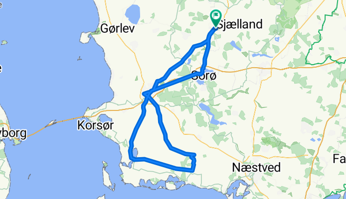
Stenlille-Slagelse-sidesporet mod Skælskør-slagelse-Sorø-Stenlille
A cycling route starting in Stenlille, Region Zealand, Denmark.
Overview
About this route
Første tur på sidesporet fra Slagelse mod Skælskør. Det ser ud til at vi fik drejet mod Næstved ved en fejl. Landevejen mod Skælskør
- -:--
- Duration
- 111.6 km
- Distance
- 212 m
- Ascent
- 212 m
- Descent
- ---
- Avg. speed
- ---
- Avg. speed
Route quality
Waytypes & surfaces along the route
Waytypes
Busy road
39.4 km
(35 %)
Cycleway
27.7 km
(25 %)
Surfaces
Paved
97.1 km
(87 %)
Unpaved
0.1 km
(<1 %)
Asphalt
96.6 km
(87 %)
Paving stones
0.5 km
(<1 %)
Continue with Bikemap
Use, edit, or download this cycling route
You would like to ride Stenlille-Slagelse-sidesporet mod Skælskør-slagelse-Sorø-Stenlille or customize it for your own trip? Here is what you can do with this Bikemap route:
Free features
- Save this route as favorite or in collections
- Copy & plan your own version of this route
- Sync your route with Garmin or Wahoo
Premium features
Free trial for 3 days, or one-time payment. More about Bikemap Premium.
- Navigate this route on iOS & Android
- Export a GPX / KML file of this route
- Create your custom printout (try it for free)
- Download this route for offline navigation
Discover more Premium features.
Get Bikemap PremiumFrom our community
Other popular routes starting in Stenlille
- Stenlille-Slagelse-sidesporet mod Skælskør-slagelse-Sorø-Stenlille
- Distance
- 111.6 km
- Ascent
- 212 m
- Descent
- 212 m
- Location
- Stenlille, Region Zealand, Denmark
- Vedde - Korsør
- Distance
- 49.8 km
- Ascent
- 144 m
- Descent
- 180 m
- Location
- Stenlille, Region Zealand, Denmark
- Vedde - Køge
- Distance
- 60.7 km
- Ascent
- 250 m
- Descent
- 284 m
- Location
- Stenlille, Region Zealand, Denmark
- Allindelille
- Distance
- 22.2 km
- Ascent
- 103 m
- Descent
- 105 m
- Location
- Stenlille, Region Zealand, Denmark
- Jyderup - St. Merløse (4)
- Distance
- 54.5 km
- Ascent
- 354 m
- Descent
- 363 m
- Location
- Stenlille, Region Zealand, Denmark
- Fed påsketur 70 km 550 hm
- Distance
- 68.6 km
- Ascent
- 226 m
- Descent
- 225 m
- Location
- Stenlille, Region Zealand, Denmark
- Stenlille- Borup
- Distance
- 55.4 km
- Ascent
- 222 m
- Descent
- 214 m
- Location
- Stenlille, Region Zealand, Denmark
- Stenlille-Holbæk-Orø-Hammer Bakker-Munkholmbroen-Tølløse
- Distance
- 88.1 km
- Ascent
- 256 m
- Descent
- 256 m
- Location
- Stenlille, Region Zealand, Denmark