

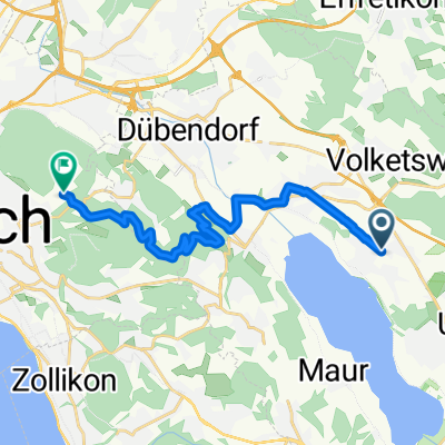
Greifensee Strasse 65, Nänikon nach Greifensee Strasse 65, Nänikon
A cycling route starting in Nänikon, Canton of Zurich, Switzerland.
Overview
About this route
- 1 h 47 min
- Duration
- 25.5 km
- Distance
- 174 m
- Ascent
- 173 m
- Descent
- 14.3 km/h
- Avg. speed
- 560 m
- Max. altitude

Route quality
Waytypes & surfaces along the route
Waytypes
Track
9.4 km
(37 %)
Quiet road
5.4 km
(21 %)
Surfaces
Paved
20.9 km
(82 %)
Unpaved
4.1 km
(16 %)
Asphalt
19.4 km
(76 %)
Gravel
3.8 km
(15 %)
Continue with Bikemap
Use, edit, or download this cycling route
You would like to ride Greifensee Strasse 65, Nänikon nach Greifensee Strasse 65, Nänikon or customize it for your own trip? Here is what you can do with this Bikemap route:
Free features
- Save this route as favorite or in collections
- Copy & plan your own version of this route
- Sync your route with Garmin or Wahoo
Premium features
Free trial for 3 days, or one-time payment. More about Bikemap Premium.
- Navigate this route on iOS & Android
- Export a GPX / KML file of this route
- Create your custom printout (try it for free)
- Download this route for offline navigation
Discover more Premium features.
Get Bikemap PremiumFrom our community
Other popular routes starting in Nänikon
 Bluetmattstrasse, Uster nach Zentrum Meierwis 1, Greifensee
- Distance
- 0.8 km
- Ascent
- 0 m
- Descent
- 8 m
- Location
- Nänikon, Canton of Zurich, Switzerland
 Nänikon zum Zoo
- Distance
- 15.5 km
- Ascent
- 346 m
- Descent
- 183 m
- Location
- Nänikon, Canton of Zurich, Switzerland
 Route nach Zürichbergstrasse, Zürich
- Distance
- 14.2 km
- Ascent
- 258 m
- Descent
- 99 m
- Location
- Nänikon, Canton of Zurich, Switzerland
 Tüfwiesenstrasse 40, Uster nach Meierwis 7, Greifensee
- Distance
- 25.1 km
- Ascent
- 294 m
- Descent
- 290 m
- Location
- Nänikon, Canton of Zurich, Switzerland
 Tüfwiesenstrasse 48, Nänikon to Tüfwiesenstrasse 46, Nänikon
- Distance
- 36.8 km
- Ascent
- 121 m
- Descent
- 119 m
- Location
- Nänikon, Canton of Zurich, Switzerland
 Tüfwiesenstrasse 26, Nänikon to Tüfwiesenstrasse 52, Nänikon
- Distance
- 6.9 km
- Ascent
- 42 m
- Descent
- 41 m
- Location
- Nänikon, Canton of Zurich, Switzerland
 Pfäffikersee Tour Variante 2
- Distance
- 38.8 km
- Ascent
- 460 m
- Descent
- 459 m
- Location
- Nänikon, Canton of Zurich, Switzerland
 Tüfwiesenstrasse 40, Uster nach A1, Wallisellen
- Distance
- 10.9 km
- Ascent
- 34 m
- Descent
- 45 m
- Location
- Nänikon, Canton of Zurich, Switzerland
Open it in the app