Wypad i rozpoznanie
A cycling route starting in Ostrołęka, Masovian Voivodeship, Poland.
Overview
About this route
- -:--
- Duration
- 162.1 km
- Distance
- 264 m
- Ascent
- 264 m
- Descent
- ---
- Avg. speed
- ---
- Max. altitude
Route quality
Waytypes & surfaces along the route
Waytypes
Road
43.8 km
(27 %)
Quiet road
24.3 km
(15 %)
Surfaces
Paved
132.9 km
(82 %)
Unpaved
8.1 km
(5 %)
Asphalt
132.9 km
(82 %)
Unpaved (undefined)
6.5 km
(4 %)
Route highlights
Points of interest along the route
Point of interest after 16.9 km
Uzupełniamy zapasy.
Point of interest after 49.8 km
Bunt w ekipie :) Zjadamy wszystko co mamy.
Point of interest after 55.6 km
Odnowienie zapasów. No prawie ... bo większość szybko znika :)
Point of interest after 63.2 km
O nie tędy nie jedziemy. Podobno południowa trasa jest lepsza.
Point of interest after 84.9 km
Ciepły obiad. Regeneracja energii.
Point of interest after 108.4 km
Narada.
Point of interest after 121.6 km
Porzucamy część grupy :(
Point of interest after 126.4 km
Może włączymy światła ?
Continue with Bikemap
Use, edit, or download this cycling route
You would like to ride Wypad i rozpoznanie or customize it for your own trip? Here is what you can do with this Bikemap route:
Free features
- Save this route as favorite or in collections
- Copy & plan your own version of this route
- Split it into stages to create a multi-day tour
- Sync your route with Garmin or Wahoo
Premium features
Free trial for 3 days, or one-time payment. More about Bikemap Premium.
- Navigate this route on iOS & Android
- Export a GPX / KML file of this route
- Create your custom printout (try it for free)
- Download this route for offline navigation
Discover more Premium features.
Get Bikemap PremiumFrom our community
Other popular routes starting in Ostrołęka
Wypad i rozpoznanie- Distance
- 162.1 km
- Ascent
- 264 m
- Descent
- 264 m
- Location
- Ostrołęka, Masovian Voivodeship, Poland
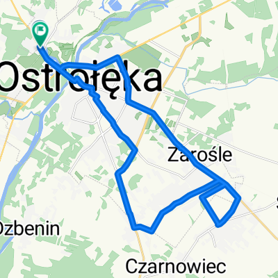
Sobótkowa do Generała Zygmunta Padlewskiego- Distance
- 19.7 km
- Ascent
- 169 m
- Descent
- 199 m
- Location
- Ostrołęka, Masovian Voivodeship, Poland
MP 68 - GOOD Route - Pętla Rzekuń- Distance
- 2.7 km
- Ascent
- 4 m
- Descent
- 4 m
- Location
- Ostrołęka, Masovian Voivodeship, Poland
MP 196 - BAD ROUTE- Distance
- 5.9 km
- Ascent
- 18 m
- Descent
- 12 m
- Location
- Ostrołęka, Masovian Voivodeship, Poland
MP 196 - GOOD Route- Distance
- 6.3 km
- Ascent
- 16 m
- Descent
- 12 m
- Location
- Ostrołęka, Masovian Voivodeship, Poland
MP 6.1 OSTROŁĘKA - FINAŁOWA- Distance
- 6.1 km
- Ascent
- 9 m
- Descent
- 8 m
- Location
- Ostrołęka, Masovian Voivodeship, Poland
GjwsD trasa 4- Distance
- 61.3 km
- Ascent
- 82 m
- Descent
- 83 m
- Location
- Ostrołęka, Masovian Voivodeship, Poland
Ostrołęka - Wola Rasztowska- Distance
- 79.8 km
- Ascent
- 113 m
- Descent
- 119 m
- Location
- Ostrołęka, Masovian Voivodeship, Poland
Open it in the app

