

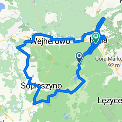
Reda - Darżlubie - Jastrzębia Góra - Reda
A cycling route starting in Reda, Pomeranian Voivodeship, Poland.
Overview
About this route
The terrain surprised me. The highest elevation is about 100 m above sea level and is already at 20 km. After that, there are very small elevation changes. Only a higher climb is after Sławutówek. In summary, the route is just right for medium-distance cyclists (like me). For professionals, that is, those who do more than 100 km a day, it will be a piece of cake.
- -:--
- Duration
- 78 km
- Distance
- 265 m
- Ascent
- 263 m
- Descent
- ---
- Avg. speed
- ---
- Max. altitude

Route quality
Waytypes & surfaces along the route
Waytypes
Road
17.9 km
(23 %)
Quiet road
15.6 km
(20 %)
Surfaces
Paved
59.3 km
(76 %)
Unpaved
4.7 km
(6 %)
Asphalt
58.5 km
(75 %)
Unpaved (undefined)
2.3 km
(3 %)
Continue with Bikemap
Use, edit, or download this cycling route
You would like to ride Reda - Darżlubie - Jastrzębia Góra - Reda or customize it for your own trip? Here is what you can do with this Bikemap route:
Free features
- Save this route as favorite or in collections
- Copy & plan your own version of this route
- Sync your route with Garmin or Wahoo
Premium features
Free trial for 3 days, or one-time payment. More about Bikemap Premium.
- Navigate this route on iOS & Android
- Export a GPX / KML file of this route
- Create your custom printout (try it for free)
- Download this route for offline navigation
Discover more Premium features.
Get Bikemap PremiumFrom our community
Other popular routes starting in Reda
 Reda - Kamienica Szlachecka wybudowanie
- Distance
- 60.8 km
- Ascent
- 535 m
- Descent
- 335 m
- Location
- Reda, Pomeranian Voivodeship, Poland
 Reda - Darżlubie - Starzyno - Karwia - Hel - Puck - Mrzezino - Rumia - Reda-
- Distance
- 186.4 km
- Ascent
- 241 m
- Descent
- 239 m
- Location
- Reda, Pomeranian Voivodeship, Poland
 Reda Marianowo - Nowy Dwór Wejherowski - Przetoczyno - Gowino - Zibertowo - Wejherowo - Reda
- Distance
- 58.7 km
- Ascent
- 482 m
- Descent
- 569 m
- Location
- Reda, Pomeranian Voivodeship, Poland
 Bieszkowice właściwa
- Distance
- 14.6 km
- Ascent
- 304 m
- Descent
- 145 m
- Location
- Reda, Pomeranian Voivodeship, Poland
 Obwodowa 9, Reda do Garncarska 7–13, Reda
- Distance
- 20.4 km
- Ascent
- 3 m
- Descent
- 16 m
- Location
- Reda, Pomeranian Voivodeship, Poland
 Reda - Darżlubie - Jastrzębia Góra - Reda
- Distance
- 78 km
- Ascent
- 265 m
- Descent
- 263 m
- Location
- Reda, Pomeranian Voivodeship, Poland
 Reda Jarowa - Zbychowo
- Distance
- 8.4 km
- Ascent
- 129 m
- Descent
- 69 m
- Location
- Reda, Pomeranian Voivodeship, Poland
 Z Redy do Władysławowa, z Władysławowa na Hel i z powrotem
- Distance
- 91.5 km
- Ascent
- 156 m
- Descent
- 144 m
- Location
- Reda, Pomeranian Voivodeship, Poland
Open it in the app