

Day 5a shorter Kilmartin to Claonaig ferry
A cycling route starting in Lochgilphead, Scotland, United Kingdom.
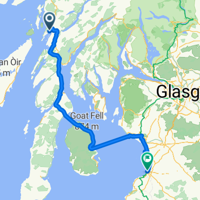
Overview
About this route
- 6 h 59 min
- Duration
- 54.2 km
- Distance
- 498 m
- Ascent
- 534 m
- Descent
- 7.8 km/h
- Avg. speed
- 128 m
- Max. altitude

Route quality
Waytypes & surfaces along the route
Waytypes
Cycleway
32.5 km
(60 %)
Quiet road
3.3 km
(6 %)
Surfaces
Paved
26 km
(48 %)
Unpaved
2.2 km
(4 %)
Asphalt
26 km
(48 %)
Gravel
2.2 km
(4 %)
Undefined
26 km
(48 %)
Continue with Bikemap
Use, edit, or download this cycling route
You would like to ride Day 5a shorter Kilmartin to Claonaig ferry or customize it for your own trip? Here is what you can do with this Bikemap route:
Free features
- Save this route as favorite or in collections
- Copy & plan your own version of this route
- Sync your route with Garmin or Wahoo
Premium features
Free trial for 3 days, or one-time payment. More about Bikemap Premium.
- Navigate this route on iOS & Android
- Export a GPX / KML file of this route
- Create your custom printout (try it for free)
- Download this route for offline navigation
Discover more Premium features.
Get Bikemap PremiumFrom our community
Other popular routes starting in Lochgilphead
 LEJO'G 19 Crinan to Oban
- Distance
- 79.9 km
- Ascent
- 1,251 m
- Descent
- 1,222 m
- Location
- Lochgilphead, Scotland, United Kingdom
 Cairnbaan Achnamara loop
- Distance
- 20.5 km
- Ascent
- 290 m
- Descent
- 292 m
- Location
- Lochgilphead, Scotland, United Kingdom
 ESC 111: Nördl. Kintyre, Islay und Jura per Rad und Schiff
- Distance
- 173.2 km
- Ascent
- 539 m
- Descent
- 540 m
- Location
- Lochgilphead, Scotland, United Kingdom
 Day 4
Day 4- Distance
- 68.5 km
- Ascent
- 444 m
- Descent
- 452 m
- Location
- Lochgilphead, Scotland, United Kingdom
 05 - Ardfern to Ayr
- Distance
- 153.6 km
- Ascent
- 573 m
- Descent
- 574 m
- Location
- Lochgilphead, Scotland, United Kingdom
 Crinan - Tayvallich loop
- Distance
- 37.3 km
- Ascent
- 385 m
- Descent
- 385 m
- Location
- Lochgilphead, Scotland, United Kingdom
 Schotland, 18 juni 2012, Glendaruel-Rothesay
- Distance
- 46 km
- Ascent
- 265 m
- Descent
- 293 m
- Location
- Lochgilphead, Scotland, United Kingdom
 4.1 Ford - Oban
- Distance
- 57.3 km
- Ascent
- 924 m
- Descent
- 963 m
- Location
- Lochgilphead, Scotland, United Kingdom
Open it in the app