

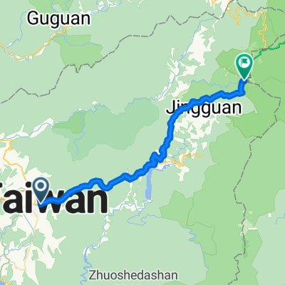
埔里至武嶺
A cycling route starting in Puli, Taiwan, Taiwan.
Overview
About this route
鐵屁屁
- -:--
- Duration
- 53 km
- Distance
- 3,534 m
- Ascent
- 1,546 m
- Descent
- ---
- Avg. speed
- 2,466 m
- Max. altitude

Route quality
Waytypes & surfaces along the route
Waytypes
Busy road
44.7 km
(84 %)
Path
4.3 km
(8 %)
Surfaces
Paved
27 km
(51 %)
Asphalt
27 km
(51 %)
Undefined
25.9 km
(49 %)
Continue with Bikemap
Use, edit, or download this cycling route
You would like to ride 埔里至武嶺 or customize it for your own trip? Here is what you can do with this Bikemap route:
Free features
- Save this route as favorite or in collections
- Copy & plan your own version of this route
- Sync your route with Garmin or Wahoo
Premium features
Free trial for 3 days, or one-time payment. More about Bikemap Premium.
- Navigate this route on iOS & Android
- Export a GPX / KML file of this route
- Create your custom printout (try it for free)
- Download this route for offline navigation
Discover more Premium features.
Get Bikemap PremiumFrom our community
Other popular routes starting in Puli
 EMTB-糯米橋-芙蓉谷瀑布-阿冷坑林道-清流部落 | E-Bike Ride | Strava
- Distance
- 38.4 km
- Ascent
- 1,605 m
- Descent
- 1,606 m
- Location
- Puli, Taiwan, Taiwan
 單車遊日月潭~環潭記
- Distance
- 30.8 km
- Ascent
- 1,420 m
- Descent
- 1,418 m
- Location
- Puli, Taiwan, Taiwan
 C03 埔里-合歡山-武嶺
- Distance
- 51.6 km
- Ascent
- 3,573 m
- Descent
- 1,569 m
- Location
- Puli, Taiwan, Taiwan
 中橫-埔里到花蓮
- Distance
- 168.4 km
- Ascent
- 3,406 m
- Descent
- 3,825 m
- Location
- Puli, Taiwan, Taiwan
 <慢騎>環日月潭991226
- Distance
- 29.4 km
- Ascent
- 520 m
- Descent
- 520 m
- Location
- Puli, Taiwan, Taiwan
 埔里到武嶺
埔里到武嶺- Distance
- 53.8 km
- Ascent
- 3,442 m
- Descent
- 1,313 m
- Location
- Puli, Taiwan, Taiwan
 埔里地理中心碑-武嶺
- Distance
- 52.8 km
- Ascent
- 3,551 m
- Descent
- 1,569 m
- Location
- Puli, Taiwan, Taiwan
 埔里經中橫至花蓮
- Distance
- 143.2 km
- Ascent
- 4,026 m
- Descent
- 4,439 m
- Location
- Puli, Taiwan, Taiwan
Open it in the app