
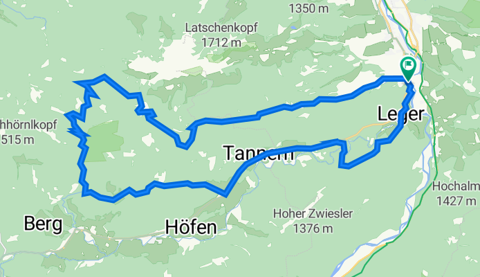
Reichenau-Schwarzenbach (Jachau) (36,1 km)
A cycling route starting in Lenggries, Bavaria, Germany.
Overview
About this route
It was wet. I rode the route in reverse, but this seems more favorable to me. The trail from Tanneralm is rideable; you may have to lift the bike over the streams, depending on your courage. The hiking path from/to the upper Orterer Alm is definitely not rideable, meaning you have to push the bike unpleasantly. During alpine farming operations, access may not be possible. The path over Rautalm is probably the better option. Despite 'only' about 800 meters of elevation gain, the climbs are tough. The gorges are the highlight, but so is the panorama from Tanneralm. Not much 'traffic' up there.
- -:--
- Duration
- 35.5 km
- Distance
- 1,154 m
- Ascent
- 1,153 m
- Descent
- ---
- Avg. speed
- 1,319 m
- Max. altitude

Route photos
 (36,1 km)\"")
 (36,1 km)\"")
 (36,1 km)\"")
 (36,1 km)\"")
 (36,1 km)\"")
 (36,1 km)\"")
Continue with Bikemap
Use, edit, or download this cycling route
You would like to ride Reichenau-Schwarzenbach (Jachau) (36,1 km) or customize it for your own trip? Here is what you can do with this Bikemap route:
Free features
- Save this route as favorite or in collections
- Copy & plan your own version of this route
- Sync your route with Garmin or Wahoo
Premium features
Free trial for 3 days, or one-time payment. More about Bikemap Premium.
- Navigate this route on iOS & Android
- Export a GPX / KML file of this route
- Create your custom printout (try it for free)
- Download this route for offline navigation
Discover more Premium features.
Get Bikemap PremiumFrom our community
Other popular routes starting in Lenggries
 Reichenau-Schwarzenbach (Jachau) (36,1 km)
- Distance
- 35.5 km
- Ascent
- 1,154 m
- Descent
- 1,153 m
- Location
- Lenggries, Bavaria, Germany
 Klosterrunde Sachsenkam - Kloster Reutberg
- Distance
- 50.9 km
- Ascent
- 478 m
- Descent
- 481 m
- Location
- Lenggries, Bavaria, Germany
 Obergries - Aueralm - Obergries
- Distance
- 40.5 km
- Ascent
- 877 m
- Descent
- 875 m
- Location
- Lenggries, Bavaria, Germany
 An der Benewand entlang
- Distance
- 41.4 km
- Ascent
- 900 m
- Descent
- 908 m
- Location
- Lenggries, Bavaria, Germany
 Rosenheim - Schwaz
- Distance
- 77.9 km
- Ascent
- 1,168 m
- Descent
- 1,287 m
- Location
- Lenggries, Bavaria, Germany
 Sonntraten
- Distance
- 4.4 km
- Ascent
- 362 m
- Descent
- 344 m
- Location
- Lenggries, Bavaria, Germany
 Ronda Isaria - 2. Hälfte
- Distance
- 56.1 km
- Ascent
- 1,182 m
- Descent
- 1,217 m
- Location
- Lenggries, Bavaria, Germany
 RR Lenggries-Eng-Walchensee
- Distance
- 115.6 km
- Ascent
- 633 m
- Descent
- 630 m
- Location
- Lenggries, Bavaria, Germany
Open it in the app