

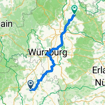
Jagst Kocher 321
A cycling route starting in Krautheim, Baden-Wurttemberg, Germany.
Overview
About this route
- -:--
- Duration
- 302.5 km
- Distance
- 3,034 m
- Ascent
- 2,998 m
- Descent
- ---
- Avg. speed
- 498 m
- Max. altitude

Route quality
Waytypes & surfaces along the route
Waytypes
Track
118 km
(39 %)
Quiet road
66.5 km
(22 %)
Surfaces
Paved
284.3 km
(94 %)
Unpaved
6 km
(2 %)
Asphalt
275.3 km
(91 %)
Paved (undefined)
6 km
(2 %)
Route highlights
Points of interest along the route
Point of interest after 59.2 km
Point of interest after 156.7 km
Continue with Bikemap
Use, edit, or download this cycling route
You would like to ride Jagst Kocher 321 or customize it for your own trip? Here is what you can do with this Bikemap route:
Free features
- Save this route as favorite or in collections
- Copy & plan your own version of this route
- Split it into stages to create a multi-day tour
- Sync your route with Garmin or Wahoo
Premium features
Free trial for 3 days, or one-time payment. More about Bikemap Premium.
- Navigate this route on iOS & Android
- Export a GPX / KML file of this route
- Create your custom printout (try it for free)
- Download this route for offline navigation
Discover more Premium features.
Get Bikemap PremiumFrom our community
Other popular routes starting in Krautheim
 Krautheim - Stadtlauringen
- Distance
- 151.7 km
- Ascent
- 1,490 m
- Descent
- 1,387 m
- Location
- Krautheim, Baden-Wurttemberg, Germany
 Krautheim BSK - Krone
- Distance
- 1.3 km
- Ascent
- 85 m
- Descent
- 11 m
- Location
- Krautheim, Baden-Wurttemberg, Germany
 Oberhalb von Marlach
- Distance
- 5 km
- Ascent
- 136 m
- Descent
- 134 m
- Location
- Krautheim, Baden-Wurttemberg, Germany
 Erlenbach-Krautheim-Widdern-Erlenbach
- Distance
- 58.1 km
- Ascent
- 522 m
- Descent
- 519 m
- Location
- Krautheim, Baden-Wurttemberg, Germany
 krautheim-Meßbach
- Distance
- 19.1 km
- Ascent
- 728 m
- Descent
- 725 m
- Location
- Krautheim, Baden-Wurttemberg, Germany
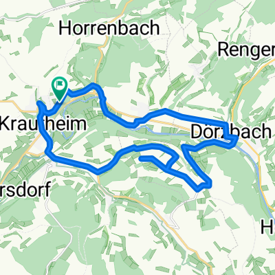
 Krautheim - Dörzbach
- Distance
- 19.2 km
- Ascent
- 46 m
- Descent
- 48 m
- Location
- Krautheim, Baden-Wurttemberg, Germany
 Ochsenfurt Würzburg Gommersdorf
- Distance
- 154.5 km
- Ascent
- 659 m
- Descent
- 596 m
- Location
- Krautheim, Baden-Wurttemberg, Germany
 Erlenbach - Heidelberg
- Distance
- 126 km
- Ascent
- 146 m
- Descent
- 290 m
- Location
- Krautheim, Baden-Wurttemberg, Germany
Open it in the app